IMAGES TAKEN NEAR TO
Grange Terrace, LANARK, ML11 8SN
Introduction
This page details the photographs taken nearby to Grange Terrace, ML11 8SN by members of the Geograph project.
The Geograph project started in 2005 with the aim of publishing, organising and preserving representative images for every square kilometre of Great Britain, Ireland and the Isle of Man.

There are currently over 7.5m images from over14,400 individuals and you can help contribute to the project by visiting https://www.geograph.org.uk
Image Map
Images are licensed for reuse under creativecommons.org/licenses/by-sa/2.0
Notes
- Clicking on the map will re-center to the selected point.
- The higher the marker number, the further away the image location is from the centre of the postcode.
Image Listing (14 Images Found)
Images are licensed for reuse under creativecommons.org/licenses/by-sa/2.0
Image
Details
Distance
2
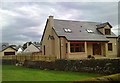
Raeburn Common
A new housing development in a road triangle near Pettinain
Image: © Richard Webb
Taken: 23 Jun 2011
0.07 miles
3
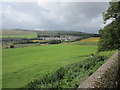
Pettinain village
A recreation field on the south side of the village. The stone house (centre) was originally the village school, built in 1887 to replace an older school near the church. It is now a private dwelling. Information from 'Village Trails in Clydesdale and Tweeddale' by Rosemary Turpie and Ian Gilchrist, Quothquan Trails 2015.
Image: © Jim Barton
Taken: 20 Oct 2019
0.08 miles
4
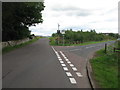
Road Junction at Pettinain
At the western end of Pettinain.
Image: © G Laird
Taken: 10 Sep 2013
0.08 miles
5
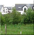
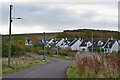
Recent housing at Pettinain
Seen from the churchyard.
Image: © Jonathan Thacker
Taken: 16 Aug 2018
0.10 miles
6
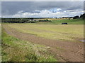
View towards Raeburn Common
Raeburn Common is the newer part of Pettinain and can be seen just to the left of the centre of the picture.
Image: © Jonathan Thacker
Taken: 16 Aug 2018
0.12 miles
8
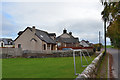
Houses at Pettinain
Houses within the triangle of roads south of the church and Bank Farm.
Image: © Jim Barton
Taken: 20 Oct 2019
0.15 miles
9
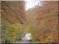
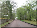
Autumn colours at Pettinain
The colour of the trees as seen in this photograph made me stop the car just in order to find my camera and take a shot !
Image: © David Hamilton
Taken: 5 Nov 2006
0.15 miles
10
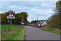
Village sign, Pettinain
The original name was Padynnane, possibly derived from Anglo-Saxon 'Pad' bird of prey and 'Innan' a dwelling place - from 'Village Trails in Clydesdale and Tweeddale' by Rosemary Turpie and Ian Gilchrist, Quothquan Trails 2015.
Image: © Jim Barton
Taken: 20 Oct 2019
0.16 miles