IMAGES TAKEN NEAR TO
Cleghorn, LANARK, ML11 8NR
Introduction
This page details the photographs taken nearby to ML11 8NR by members of the Geograph project.
The Geograph project started in 2005 with the aim of publishing, organising and preserving representative images for every square kilometre of Great Britain, Ireland and the Isle of Man.

There are currently over 7.5m images from over14,400 individuals and you can help contribute to the project by visiting https://www.geograph.org.uk
Image Map
Images are licensed for reuse under creativecommons.org/licenses/by-sa/2.0
Notes
- Clicking on the map will re-center to the selected point.
- The higher the marker number, the further away the image location is from the centre of the postcode.
Image Listing (6 Images Found)
Images are licensed for reuse under creativecommons.org/licenses/by-sa/2.0
Image
Details
Distance
1
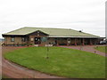
Kames Golf Club - Clubhouse
Clubhouse for two 18 holes courses near Carstairs Village.
Image: © G Laird
Taken: 23 Jan 2011
0.10 miles
2
A721 at Cowford Bridge
A plaque date the bridge from 1938
Image: © Jim Smillie
Taken: 8 Apr 2024
0.13 miles
3
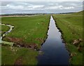
Mouse Water from Cowford Bridge
Like a large drainage ditch in this stretch
Image: © Jim Smillie
Taken: 8 Apr 2024
0.15 miles
5
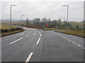
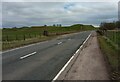
Road Junction North of Carstairs Village
Looking along the A721 from Carluke at the junction with the A70 to Carnwath (straight ahead) and Carstairs Village to the right.
I doubt that many people will now remember that until the mid 1960s this road junction looked totally different. It was in fact a very large road traffic triangular island, so large in fact that on any of the approaches to the island, you could not see the entire island. It simply looked as though you were approaching a fork in the road.
Image: © G Laird
Taken: 23 Jan 2011
0.20 miles
6
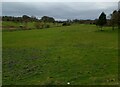
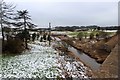
Former golf course
One of two former courses at what was Kames Country Club
Image: © Jim Smillie
Taken: 8 Apr 2024
0.20 miles