IMAGES TAKEN NEAR TO
Lowther View, LANARK, ML11 8JP
Introduction
This page details the photographs taken nearby to Lowther View, ML11 8JP by members of the Geograph project.
The Geograph project started in 2005 with the aim of publishing, organising and preserving representative images for every square kilometre of Great Britain, Ireland and the Isle of Man.

There are currently over 7.5m images from over14,400 individuals and you can help contribute to the project by visiting https://www.geograph.org.uk
Image Map
Images are licensed for reuse under creativecommons.org/licenses/by-sa/2.0
Notes
- Clicking on the map will re-center to the selected point.
- The higher the marker number, the further away the image location is from the centre of the postcode.
Image Listing (32 Images Found)
Images are licensed for reuse under creativecommons.org/licenses/by-sa/2.0
Image
Details
Distance
1
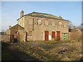
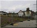
Old Primary School, Carnwath
A view of the rear from what would have been the playground. The primary school was built in 1876 and enlarged in 1913. It has been derelict for some time, although a board on the front indicates that it was used by a joinery business at some time. https://canmore.org.uk/site/316703/carnwath-140-142-main-street-primary-school, but more information is given on the Buildings at Risk Register https://www.buildingsatrisk.org.uk/details/914358 .
Image: © M J Richardson
Taken: 15 Feb 2019
0.20 miles
2
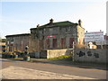
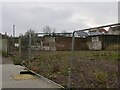
Old Primary School, Carnwath
The primary school was built in 1876 and enlarged in 1913. It has been derelict for some time, although a board on the front indicates that it was used by a joinery business at some time. https://canmore.org.uk/site/316703/carnwath-140-142-main-street-primary-school, but more information is given on the Buildings at Risk Register https://www.buildingsatrisk.org.uk/details/914358 . Mike Pennington was there 3 years earlier - there has not been much change Image The 'development opportunity' notice is on an adjacent ruinous site.
Image: © M J Richardson
Taken: 15 Feb 2019
0.20 miles
3
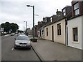
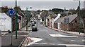
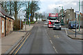
Carnwath
The western end of the street.
Image: © Richard Webb
Taken: 23 Jul 2008
0.20 miles
5
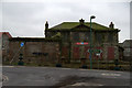
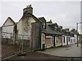
Vacant plot, Carnwath
Several houses have been demolished here and the area has been undeveloped for some time now. One of the buildings was this one: Image
Image: © Richard Webb
Taken: 2 Dec 2022
0.20 miles
7
Carnwath
Looking down Main Street from opposite John Mann Park.
Image: © Richard Webb
Taken: 14 Feb 2011
0.21 miles
9

Some hae nae meat...
A sad sight in the main street of Carnwath. I am guessing that the tremors from the seismic centre of Tesco's in Lanark have rippled through the villages of South Lanarkshire.
Image: © kim traynor
Taken: 8 Oct 2010
0.21 miles
10
A70, Carnwath Main Street
Carnwath (Gaelic: A' Chathair Nuadh; meaning "New Fort") is a moorland village on the southern edge of the Pentland Hills of South Lanarkshire. Situated about 30 miles south of both Edinburgh and Glasgow, its position on the A70 road makes it a popular choice for commuters.
Image: © David Dixon
Taken: 4 Mar 2020
0.22 miles