IMAGES TAKEN NEAR TO
Biggar Road, LANARK, ML11 8HJ
Introduction
This page details the photographs taken nearby to Biggar Road, ML11 8HJ by members of the Geograph project.
The Geograph project started in 2005 with the aim of publishing, organising and preserving representative images for every square kilometre of Great Britain, Ireland and the Isle of Man.

There are currently over 7.5m images from over14,400 individuals and you can help contribute to the project by visiting https://www.geograph.org.uk
Image Map
Images are licensed for reuse under creativecommons.org/licenses/by-sa/2.0
Notes
- Clicking on the map will re-center to the selected point.
- The higher the marker number, the further away the image location is from the centre of the postcode.
Image Listing (38 Images Found)
Images are licensed for reuse under creativecommons.org/licenses/by-sa/2.0
Image
Details
Distance
1
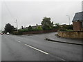
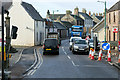
The B7016 in Carnwath
heading north in the southern section of the town.
Image: © James Denham
Taken: 4 Oct 2013
0.03 miles
2
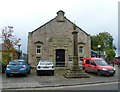
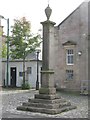
Town hall and mercat cross, Carnwath
The cross was erected by the 5th Lord Somerville in 1516 to celebrate the granting of burgh status to the village in 1514.
Image: © kim traynor
Taken: 8 Oct 2010
0.10 miles
3
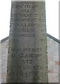
Miles from Carnwath
Distances from Edinburgh to Ayr and from Peebles to Glasgow carved on the mercat cross.
Image: © kim traynor
Taken: 8 Oct 2010
0.10 miles
4
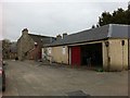
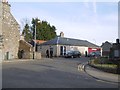
Bakery and garage, Biggar Road, Carnwath
Image: © Darrin Antrobus
Taken: 25 Mar 2013
0.10 miles
5
Carnwath Mercat Cross
The Mercat Cross is at the centre of Carnwath, set back a little where the Main Street widens to form the Market Square. It was erected by the 5th Lord of Somerville in 1516 to celebrate the granting of burgh status to the village in 1514. It gives distances along the road from Edinburgh to Ayr (mediaeval spelling 'Air') and the road from Peebles to Glasgow. The original urn on top was replaced in 1970.
Image: © G Laird
Taken: 20 Sep 2013
0.11 miles
6
Town Hall and Mercat Cross, Carnwath
The cross dates back to the 16th century; by contrast the town hall is dated 1930. See also G Laird's photograph Image
Image: © Jim Barton
Taken: 7 Jun 2019
0.11 miles
7
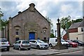
Old Freemason's Hall, Carnwath
Built as the Lockhart Lodge in 1813, it became, before its closure, the Masons Arms public house.
Image: © kim traynor
Taken: 8 Oct 2010
0.11 miles
9
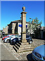
Carnwath Mercat Cross
This old cross, located by the roadside, dates back to 1516.
Image: © Mary and Angus Hogg
Taken: 25 May 2012
0.12 miles
10
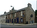
Main Street, Carnwath
Carnwath (Gaelic: A' Chathair Nuadh; meaning "New Fort") is a moorland village on the southern edge of the Pentland Hills of South Lanarkshire. Situated about 30 miles south of both Edinburgh and Glasgow, its position on the A70 road makes it a popular choice for commuters.
Image: © David Dixon
Taken: 4 Mar 2020
0.12 miles