IMAGES TAKEN NEAR TO
Birniehall, LANARK, ML11 8DF
Introduction
This page details the photographs taken nearby to Birniehall, ML11 8DF by members of the Geograph project.
The Geograph project started in 2005 with the aim of publishing, organising and preserving representative images for every square kilometre of Great Britain, Ireland and the Isle of Man.

There are currently over 7.5m images from over14,400 individuals and you can help contribute to the project by visiting https://www.geograph.org.uk
Image Map
Images are licensed for reuse under creativecommons.org/licenses/by-sa/2.0
Notes
- Clicking on the map will re-center to the selected point.
- The higher the marker number, the further away the image location is from the centre of the postcode.
Image Listing (25 Images Found)
Images are licensed for reuse under creativecommons.org/licenses/by-sa/2.0
Image
Details
Distance
2
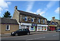
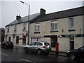
Post Office and convenience store on Main Street, Forth
Image: © JThomas
Taken: 16 Sep 2021
0.10 miles
3
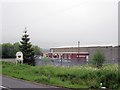
Climpy Industrial Park
Six years on from Image and little seems to have changed other than a loss of electrons from the iron in the sign - i.e. it has rusted.
Image: © Richard Webb
Taken: 8 Jun 2012
0.11 miles
5
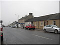
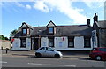
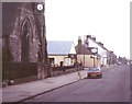
The Main Street in Forth, South Lanarkshire
Image: © James Denham
Taken: 12 Feb 2012
0.11 miles
7
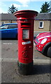
George VI postbox on Main Street, Forth
Postbox No. ML11 45.
See Image] for context.
Image: © JThomas
Taken: 16 Sep 2021
0.11 miles
8
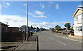
Forth: Main Street 1986
Esso petrol station between church and pub
Image: © Jim Smillie
Taken: Unknown
0.11 miles
9
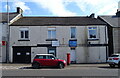
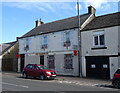
Empty shop on Main Street, Forth
Showing position of Postbox No. ML11 45.
See Image] for postbox.
Image: © JThomas
Taken: 16 Sep 2021
0.11 miles