IMAGES TAKEN NEAR TO
Manse Road, LANARK, ML11 7ST

Introduction

This page details the photographs taken nearby to Manse Road, ML11 7ST by members of the Geograph project.

The Geograph project started in 2005 with the aim of publishing, organising and preserving representative images for every square kilometre of Great Britain, Ireland and the Isle of Man.

There are currently over 7.5m images from over14,400 individuals and you can help contribute to the project by visiting https://www.geograph.org.uk

Image Map (Loading...)

MarkerMarker

Images are licensed for reuse under creativecommons.org/licenses/by-sa/2.0
Notes
  • Clicking on the map will re-center to the selected point.
  • The higher the marker number, the further away the image location is from the centre of the postcode.

Image Listing (93 Images Found)

Images are licensed for reuse under creativecommons.org/licenses/by-sa/2.0
  • ...
Image
Details
Distance
1
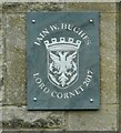
Lanimers plaque
Plaque showing this Image is the home of the Lord Cornet in 2017 - appointed to lead Lanark's annual Lanimers celebrations. See https://www.lanarklanimers.co.uk/history/a-guide-to-lanimers/lanimer-celebrations/ for more information.
Image: © Richard Sutcliffe Taken: 1 Jun 2023
0.05 miles
2
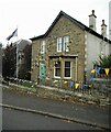
Home of a Lord Cornet
The Lanimers is an annual festival in Lanark every June. It dates back to about 1140 and centres around the duty of the Burgh officials to check that the boundary stones of the Burgh are intact. What was originally a day is now a week of celebrations. Every year a Lord Cornet is appointed to lead the events. This is the home of the Lord Cornet in 2017, as proclaimed by a plaque at the front door Image and the flag flying outside. For a fuller explanation of the Lanimers, see https://www.lanarklanimers.co.uk/history/a-guide-to-lanimers/lanimer-celebrations/.
Image: © Richard Sutcliffe Taken: 1 Jun 2023
0.05 miles
3
Mousebank Road
At the junction with Wheatland Drive.
Image: © Richard Sutcliffe Taken: 1 Jun 2023
0.08 miles
4
Lanark Fuel Express
A Gulf petrol station on the A73, West Port.
Image: © Richard Sutcliffe Taken: 1 Jun 2023
0.09 miles
5
Cottage on Park Place
A Category B listed cottage https://portal.historicenvironment.scot/designation/LB37060 dating from 1851, on the A73, Park Place.
Image: © Richard Sutcliffe Taken: 1 Jun 2023
0.09 miles
6
West Port
A72/A73 leaves Lanark.
Image: © Richard Webb Taken: 4 Nov 2011
0.09 miles
7
Service station on Westport (A73), Lanark
Image: © JThomas Taken: 16 Sep 2021
0.10 miles
8
Ordnance Survey Flush Bracket S8935
This can be found on the wall of a house - private dwelling - in West Port, Lanark. For more detail see : http://www.bench-marks.org.uk/bm500
Image: © Peter Wood Taken: 23 Sep 2014
0.10 miles
9
A73, Park Place
At the junction with Mousebank Road.
Image: © Richard Sutcliffe Taken: 1 Jun 2023
0.10 miles
10
Former Church in Hope Street Lanark
Viewed from the south and now used by the Clydesdale Housing Association.
Image: © Peter Wood Taken: 23 Sep 2014
0.11 miles
  • ...