IMAGES TAKEN NEAR TO
Mousebank Road, LANARK, ML11 7RA

Introduction

This page details the photographs taken nearby to Mousebank Road, ML11 7RA by members of the Geograph project.

The Geograph project started in 2005 with the aim of publishing, organising and preserving representative images for every square kilometre of Great Britain, Ireland and the Isle of Man.

There are currently over 7.5m images from over14,400 individuals and you can help contribute to the project by visiting https://www.geograph.org.uk

Image Map


Images are licensed for reuse under creativecommons.org/licenses/by-sa/2.0
Notes
  • Clicking on the map will re-center to the selected point.
  • The higher the marker number, the further away the image location is from the centre of the postcode.

Image Listing (9 Images Found)

Images are licensed for reuse under creativecommons.org/licenses/by-sa/2.0
Image
Details
Distance
1
Mousebank Road in the summer
There was a lot of strong sunlight coming from the west in this shot.
Image: © David Hamilton Taken: 9 Aug 2007
0.07 miles
2
Mousebank Road at Ridgepark
The view down Mousebank Road, looking towards the area just above Mousebank Farm.
Image: © David Hamilton Taken: 9 Aug 2007
0.15 miles
3
The Stey Brae
The steep hill down from Lanark towards the Mouse valley and Lockhart Mill. The glasshouses in the valley were used for tomato growing.
Image: © James Allan Taken: Unknown
0.17 miles
4
The Stey Brae, Lanark 2007
Looking a great deal more overgrown nowadays than in the first photo on this web-page, due to the 45 year time gap.
Image: © David Hamilton Taken: 9 Aug 2007
0.22 miles
5
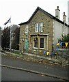
Home of a Lord Cornet
The Lanimers is an annual festival in Lanark every June. It dates back to about 1140 and centres around the duty of the Burgh officials to check that the boundary stones of the Burgh are intact. What was originally a day is now a week of celebrations. Every year a Lord Cornet is appointed to lead the events. This is the home of the Lord Cornet in 2017, as proclaimed by a plaque at the front door Image and the flag flying outside. For a fuller explanation of the Lanimers, see https://www.lanarklanimers.co.uk/history/a-guide-to-lanimers/lanimer-celebrations/.
Image: © Richard Sutcliffe Taken: 1 Jun 2023
0.24 miles
6
Stey Brae
Stey Brae ('Steep slope', in Scots) just outside Lanark, leading down to the valley of the Mouse Water. Some evening sunlight filters through the trees.
Image: © Alan O'Dowd Taken: 21 Jul 2016
0.24 miles
7
Bottom of the Stey Brae
A sign points the way to Stey Brae ('Steep slope', in Scots) just outside Lanark, in the valley of the Mouse Water.
Image: © Alan O'Dowd Taken: 21 Jul 2016
0.24 miles
8
Mouse Water from the air
A tributary of the Clyde, north west of Lanark.
Image: © Thomas Nugent Taken: 8 Dec 2017
0.24 miles
9
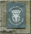
Lanimers plaque
Plaque showing this Image is the home of the Lord Cornet in 2017 - appointed to lead Lanark's annual Lanimers celebrations. See https://www.lanarklanimers.co.uk/history/a-guide-to-lanimers/lanimer-celebrations/ for more information.
Image: © Richard Sutcliffe Taken: 1 Jun 2023
0.24 miles