IMAGES TAKEN NEAR TO
Wide Close, LANARK, ML11 7LX
Introduction
This page details the photographs taken nearby to Wide Close, ML11 7LX by members of the Geograph project.
The Geograph project started in 2005 with the aim of publishing, organising and preserving representative images for every square kilometre of Great Britain, Ireland and the Isle of Man.

There are currently over 7.5m images from over14,400 individuals and you can help contribute to the project by visiting https://www.geograph.org.uk
Image Map
Images are licensed for reuse under creativecommons.org/licenses/by-sa/2.0
Notes
- Clicking on the map will re-center to the selected point.
- The higher the marker number, the further away the image location is from the centre of the postcode.
Image Listing (119 Images Found)
Images are licensed for reuse under creativecommons.org/licenses/by-sa/2.0
Image
Details
Distance
1
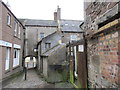
Wide Close narrows
Wide Close connects to Bloomgate through an archway.
Image: © Jonathan Thacker
Taken: 3 Nov 2017
0.02 miles
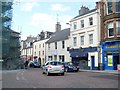
2

Wide Close
A shortcut towards the High Street.
Image: © Ross Watson
Taken: 5 Aug 2013
0.02 miles
3
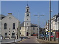
St. Nicolas' Parish Church
St. Nicolas' Parish Church stands at the bottom of the high street. The church bell is believed to date from 1110, and may be one of the oldest church bells in the world. It was moved from The Old Church of St Kentigern when St. Nicolas's Church was built in 1774. It has been recast four times, including 1659 and 1983. There is an 8-foot (2.45 m) statue of William Wallace in the steeple. This was sculpted by Robert Forrest, from an ancient drawing in the possession of the Society of Antiquaries.
This is the view towards the bottom of the High Street.
Image: © Rude Health
Taken: 9 Jun 2013
0.03 miles
4
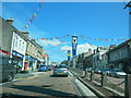
High St, Lanark, decked out for Lanimer Day
Image: © John Lord
Taken: 6 Jun 2014
0.03 miles
5
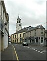
St Nicholas Parish Church
The Category B listed church https://portal.historicenvironment.scot/designation/LB36981 dates from 1774, with 19th century alterations. See https://www.lanark-stnicholas.co.uk/lanark-church-history.php for more information.
The 19th century building on the right is Category C listed https://portal.historicenvironment.scot/designation/LB36931.
Image: © Richard Sutcliffe
Taken: 1 Jun 2023
0.03 miles
7
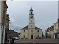
The Church of St Nicholas at Lanark
Viewed from the east.
Image: © Peter Wood
Taken: 23 Sep 2014
0.04 miles
8

St Nicholas' Church, Lanark
"Though parts of the church date back to the 12th Century, most of St. Nicholas Church, Lanark date from 1774. The tower was built by money from the local council and still belongs to the town. The church was originally known simply as the Old Parish Church." www.scran.ac.uk/000-000-594-961-C See also Image On the left is the east side of Lanark Tolbooth http://canmore.rcahms.gov.uk/en/site/46587/details/lanark+high+street+tolbooth/ .
Image: © Derek Harper
Taken: 5 Jul 2005
0.04 miles
9
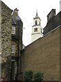
St Nicolas, Lanark
View from a courtyard - outside The Courtyard cafe.
Image: © Richard Webb
Taken: 4 Oct 2014
0.04 miles
10
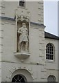
Statue of William Wallace on the tower of St. Nicholas' church
The statue was carved in 1817 by Robert Forrest and placed here in 1822.
Image: © Jonathan Thacker
Taken: 3 Nov 2017
0.04 miles