IMAGES TAKEN NEAR TO
Orchard Brae, LANARK, ML11 0RB
Introduction
This page details the photographs taken nearby to Orchard Brae, ML11 0RB by members of the Geograph project.
The Geograph project started in 2005 with the aim of publishing, organising and preserving representative images for every square kilometre of Great Britain, Ireland and the Isle of Man.

There are currently over 7.5m images from over14,400 individuals and you can help contribute to the project by visiting https://www.geograph.org.uk
Image Map (Loading...)


Getting Data...Please wait
Leaflet Map data © OpenStreetMap
Images are licensed for reuse under creativecommons.org/licenses/by-sa/2.0
Notes
- Clicking on the map will re-center to the selected point.
- The higher the marker number, the further away the image location is from the centre of the postcode.
Image Listing (135 Images Found)
Images are licensed for reuse under creativecommons.org/licenses/by-sa/2.0
Image
Details
Distance
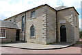
8
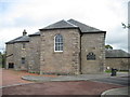
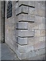
Douglas Valley Church St Brides Braehead
This church is at the end of Braehead. This is also called St Brides so i presume it is the "new" church built "some way off" from the old church.
Image: © Martin Dawes
Taken: 29 Aug 2013
0.03 miles
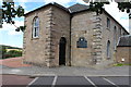
9
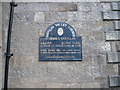
Church Notice Board. St Brides. Douglas
Image: © Martin Dawes
Taken: 29 Aug 2013
0.03 miles