IMAGES TAKEN NEAR TO
Strathaven Road, LANARK, ML11 0JB
Introduction
This page details the photographs taken nearby to Strathaven Road, ML11 0JB by members of the Geograph project.
The Geograph project started in 2005 with the aim of publishing, organising and preserving representative images for every square kilometre of Great Britain, Ireland and the Isle of Man.

There are currently over 7.5m images from over14,400 individuals and you can help contribute to the project by visiting https://www.geograph.org.uk
Image Map
Images are licensed for reuse under creativecommons.org/licenses/by-sa/2.0
Notes
- Clicking on the map will re-center to the selected point.
- The higher the marker number, the further away the image location is from the centre of the postcode.
Image Listing (10 Images Found)
Images are licensed for reuse under creativecommons.org/licenses/by-sa/2.0
Image
Details
Distance
2
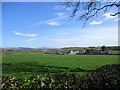
Farmland at Boghead
Boghead is a small hamlet north-west of Lesmahagow.
Image: © Alan O'Dowd
Taken: 18 Apr 2020
0.02 miles
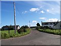
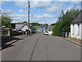
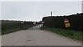
3
Strathaven Road, Boghead
On the B7086 south-west of Kirkmuirhill.
Image: © G Laird
Taken: 16 Aug 2013
0.03 miles
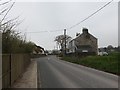
4
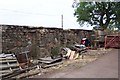
Remains of Smithy, Boghead
The only remaining 2 walls of the old smithy, on the Strathaven road, Boghead
Image: © -
Taken: 22 Jul 2006
0.06 miles
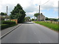
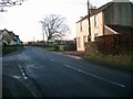
5
Lesmahagow Road, Boghead
Looking towards the intersection with the B7086.
Image: © G Laird
Taken: 16 Aug 2013
0.09 miles
8
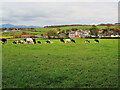
A field of grazing cows near Boghead village
Image: © wrobison
Taken: 15 Oct 2020
0.15 miles
9
Dunduff Quarry exit
Closed up (local holiday). "No children on site" - try the next square, there is a primary school there.
Image: © Richard Webb
Taken: 21 Apr 2014
0.18 miles