IMAGES TAKEN NEAR TO
Lesmahagow, LANARK, ML11 0HH
Introduction
This page details the photographs taken nearby to ML11 0HH by members of the Geograph project.
The Geograph project started in 2005 with the aim of publishing, organising and preserving representative images for every square kilometre of Great Britain, Ireland and the Isle of Man.

There are currently over 7.5m images from over14,400 individuals and you can help contribute to the project by visiting https://www.geograph.org.uk
Image Map
Images are licensed for reuse under creativecommons.org/licenses/by-sa/2.0
Notes
- Clicking on the map will re-center to the selected point.
- The higher the marker number, the further away the image location is from the centre of the postcode.
Image Listing (5 Images Found)
Images are licensed for reuse under creativecommons.org/licenses/by-sa/2.0
Image
Details
Distance
1
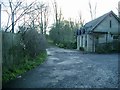
Entrance to the former Birkwood Hospital
Image: © Gordon Brown
Taken: 5 Dec 2006
0.05 miles
2
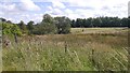
Wetland, Lesmahagow
Looking towards the redeveloped site of Birkwood Hospital.
Image: © Richard Webb
Taken: 15 Aug 2017
0.07 miles
3
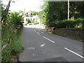
Bridge over the Kilhall Burn
Also entering Lesmahagow from the South-West. This is the reverse view to Image
Image: © G Laird
Taken: 16 Aug 2013
0.09 miles
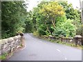
5
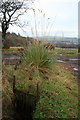
Track-side Drain
Near Birkdale.
Not the place I expected to see a clump of pampas-grass.
Image: © David Lally
Taken: 13 Nov 2008
0.23 miles