IMAGES TAKEN NEAR TO
High Kype Road, STRATHAVEN, ML10 6UQ
Introduction
This page details the photographs taken nearby to High Kype Road, ML10 6UQ by members of the Geograph project.
The Geograph project started in 2005 with the aim of publishing, organising and preserving representative images for every square kilometre of Great Britain, Ireland and the Isle of Man.

There are currently over 7.5m images from over14,400 individuals and you can help contribute to the project by visiting https://www.geograph.org.uk
Image Map
Images are licensed for reuse under creativecommons.org/licenses/by-sa/2.0
Notes
- Clicking on the map will re-center to the selected point.
- The higher the marker number, the further away the image location is from the centre of the postcode.
Image Listing (9 Images Found)
Images are licensed for reuse under creativecommons.org/licenses/by-sa/2.0
Image
Details
Distance
1
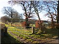
Road to Dalefield
There was once a house, Dalefield, up this farm road.
Image: © Richard Webb
Taken: 23 Nov 2013
0.06 miles
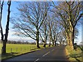
3
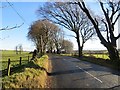
B7086
Beech lined road near Castlebrocket. The road used to be the A726.
Image: © Richard Webb
Taken: 23 Nov 2013
0.19 miles
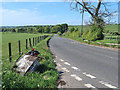
5
B7086
Beech lined road, Castlebrocket.
Image: © Richard Webb
Taken: 23 Nov 2013
0.21 miles
6
Strathaven to Kirkmuirhill road near Sandford
A road through farming country
Image: © wrobison
Taken: 27 May 2020
0.21 miles

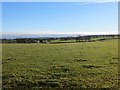
8
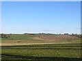
Fields, Castlebrocket
Grassland at about 200m above sea level.
Image: © Richard Webb
Taken: 23 Nov 2013
0.24 miles
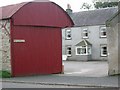
9

Entrance to the house known as 'St Oswald Chapel'
Image: © Gordon Brown
Taken: 22 Oct 2008
0.25 miles