IMAGES TAKEN NEAR TO
Kensington Drive, MILTON KEYNES, MK8 9AB
Introduction
This page details the photographs taken nearby to Kensington Drive, MK8 9AB by members of the Geograph project.
The Geograph project started in 2005 with the aim of publishing, organising and preserving representative images for every square kilometre of Great Britain, Ireland and the Isle of Man.

There are currently over 7.5m images from over14,400 individuals and you can help contribute to the project by visiting https://www.geograph.org.uk
Image Map
Images are licensed for reuse under creativecommons.org/licenses/by-sa/2.0
Notes
- Clicking on the map will re-center to the selected point.
- The higher the marker number, the further away the image location is from the centre of the postcode.
Image Listing (6 Images Found)
Images are licensed for reuse under creativecommons.org/licenses/by-sa/2.0
Image
Details
Distance
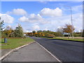
1
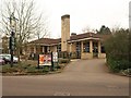
The Grebe, Great Holm
On Kensington Drive at the north end of Great Holm, near the junction with Dansteed Way.
Image: © Derek Harper
Taken: 4 Feb 2011
0.03 miles
2
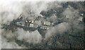
Milton Keynes from the air
Looking down on the Wymbush industrial area from a Birmingham bound flight from Prague.
Image: © Thomas Nugent
Taken: 11 Feb 2022
0.18 miles
3
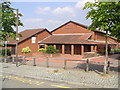
Two Mile Ash Middle School
The middle school just across from the shops on Two Mile Ash.
Image: © Mr Biz
Taken: 25 Jul 2006
0.18 miles
4
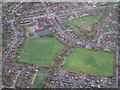
Two Mile Ash Middle School and Playing Fields
Two Mile Ash Middle School in Milton Keynes. An aerial image taken from a height of around 1500ft above ground level.
Image: © Mike Belch
Taken: 19 Nov 2000
0.18 miles
6
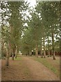
Tree-lined path, Great Holm
Lined with pines, a path leads away from Kensington Drive towards Burghley Court.
Image: © Derek Harper
Taken: 4 Feb 2011
0.22 miles