IMAGES TAKEN NEAR TO
Garamonde Drive, MILTON KEYNES, MK8 8LF
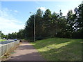
Introduction
This page details the photographs taken nearby to Garamonde Drive, MK8 8LF by members of the Geograph project.
The Geograph project started in 2005 with the aim of publishing, organising and preserving representative images for every square kilometre of Great Britain, Ireland and the Isle of Man.

There are currently over 7.5m images from over14,400 individuals and you can help contribute to the project by visiting https://www.geograph.org.uk
Image Map
Images are licensed for reuse under creativecommons.org/licenses/by-sa/2.0
Notes
- Clicking on the map will re-center to the selected point.
- The higher the marker number, the further away the image location is from the centre of the postcode.
Image Listing (8 Images Found)
Images are licensed for reuse under creativecommons.org/licenses/by-sa/2.0
Image
Details
Distance
1
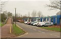
Alston Drive, Bradwell
A row of business premises. On the left, a ramp leads to a footbridge over the A5.
Image: © Derek Harper
Taken: 4 Feb 2011
0.10 miles
2
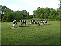
Concrete Cows
Created by Liz Leyh, the famous concrete cows of Milton Keynes now lie in a grassy meadow at the side of the A5 on the northwest corner of the town.
Image: © Stuart and Fiona Jackson
Taken: 14 Jul 2005
0.17 miles
3
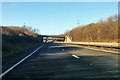
Bridge over A5, Milton Keynes
For the Abbey Hill Roundabout at the A422 junction.
Image: © Robin Webster
Taken: 7 Jan 2018
0.19 miles
6
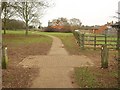
Abbey Farm Cottages
From a path circling the site of Bradwell Abbey, of which there are no medieval remains.
Image: © Derek Harper
Taken: 4 Feb 2011
0.20 miles
7
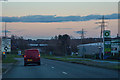
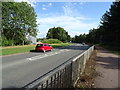
Milton Keynes : H3 Monks Way
Looking along H3 Monks Way.
Image: © Lewis Clarke
Taken: 18 Mar 2019
0.23 miles
8
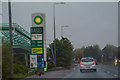
Milton Keynes : H3 Monks Way A422
Passing a BP Petrol Station.
Image: © Lewis Clarke
Taken: 6 Oct 2018
0.25 miles