IMAGES TAKEN NEAR TO
Kuri Close, MK8 1FJ

Introduction

This page details the photographs taken nearby to Kuri Close, MK8 1FJ by members of the Geograph project.

The Geograph project started in 2005 with the aim of publishing, organising and preserving representative images for every square kilometre of Great Britain, Ireland and the Isle of Man.

There are currently over 7.5m images from over14,400 individuals and you can help contribute to the project by visiting https://www.geograph.org.uk

Image Map


Images are licensed for reuse under creativecommons.org/licenses/by-sa/2.0
Notes
  • Clicking on the map will re-center to the selected point.
  • The higher the marker number, the further away the image location is from the centre of the postcode.

Image Listing (10 Images Found)

Images are licensed for reuse under creativecommons.org/licenses/by-sa/2.0
Image
Details
Distance
1
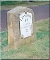
Milestone
Old milestone on what was the A5 near to Loughton, Milton Keynes. For close up view see http://www.geograph.org.uk/photo/5381107
Image: © Keith Evans Taken: 22 Apr 2017
0.05 miles
2
Path to Common Farm
Image: © Philip Jeffrey Taken: 2 Apr 2012
0.05 miles
3
Old Milestone
Old milestone on what was the A5 near to Loughton, Milton Keynes. For overall view see http://www.geograph.org.uk/photo/5381115
Image: © Keith Evans Taken: 22 Apr 2017
0.06 miles
4
Old Milestone by the former A5 in Bradwell Abbey, Milton Keynes
Metal plate attached to stone post by the UC road (was A5), in parish of Bradwell Abbey (Milton Keynes District), Watling Street; on brow of hill in open area, Two Mile Ash, on wide cut grass verge between road and cycle track, on North side of road. Milton Keynes iron plate, erected by the Holyhead Road (Hockliffe Division) turnpike trust in the 19th century. Inscription reads:- LONDON 49 STONY STRATFORD 2 Carved benchmark on top. Milestone Society National ID: BU_LH49
Image: © A Rosevear & J Higgins Taken: 11 Jul 2003
0.06 miles
5
Two Mile Ash Farm
The Farm House opposite the High Street exit of Two Mile Ash.
Image: © Mr Biz Taken: 25 Jul 2006
0.21 miles
6
Two Mile Ash Farmhouse
A casualty of the western flank developments. Looked much happier in Image
Image: © Philip Jeffrey Taken: 23 Jan 2021
0.21 miles
7
The High Street, Two Mile Ash, Milton Keynes
Image: © Cameraman Taken: 3 Jun 2011
0.22 miles
8
Road to nowhere
Yet. plenty of houses coming soon.
Image: © Philip Jeffrey Taken: 23 Jan 2021
0.22 miles
9
Shenley Hill Farm Paddock
A view down too Shenley Hill Farm, with access road and paddock in the foreground
Image: © Mr Biz Taken: 25 Jul 2006
0.22 miles
10
Path through Lady Marjorie's Gorse
Image: © Philip Jeffrey Taken: 23 Jan 2021
0.24 miles