IMAGES TAKEN NEAR TO
Barrosa Way, MILTON KEYNES, MK8 1BX
Introduction
This page details the photographs taken nearby to Barrosa Way, MK8 1BX by members of the Geograph project.
The Geograph project started in 2005 with the aim of publishing, organising and preserving representative images for every square kilometre of Great Britain, Ireland and the Isle of Man.

There are currently over 7.5m images from over14,400 individuals and you can help contribute to the project by visiting https://www.geograph.org.uk
Image Map
Images are licensed for reuse under creativecommons.org/licenses/by-sa/2.0
Notes
- Clicking on the map will re-center to the selected point.
- The higher the marker number, the further away the image location is from the centre of the postcode.
Image Listing (8 Images Found)
Images are licensed for reuse under creativecommons.org/licenses/by-sa/2.0
Image
Details
Distance
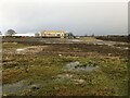
1
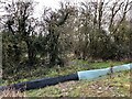
Track through to the North Buckinghamshire Way
Image: © Philip Jeffrey
Taken: 23 Jan 2021
0.06 miles
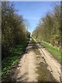
4
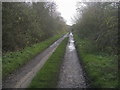
North Bucks Way
North Bucks Way heading down towards Whitehouse Farm
Image: © Shaun Ferguson
Taken: 20 Nov 2015
0.13 miles
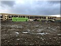
5
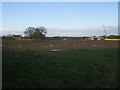
Whitehouse Farm
Building groundwork starting to surround Whitehouse Farm
Image: © Shaun Ferguson
Taken: 20 Nov 2015
0.14 miles
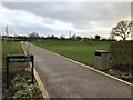
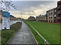
8
Whitehouse Medical Centre
And currently COVID vaccination centre
Image: © Philip Jeffrey
Taken: 23 Jan 2021
0.22 miles