IMAGES TAKEN NEAR TO
Nicholson Grove, MILTON KEYNES, MK8 0NF
Introduction
This page details the photographs taken nearby to Nicholson Grove, MK8 0NF by members of the Geograph project.
The Geograph project started in 2005 with the aim of publishing, organising and preserving representative images for every square kilometre of Great Britain, Ireland and the Isle of Man.

There are currently over 7.5m images from over14,400 individuals and you can help contribute to the project by visiting https://www.geograph.org.uk
Image Map
Images are licensed for reuse under creativecommons.org/licenses/by-sa/2.0
Notes
- Clicking on the map will re-center to the selected point.
- The higher the marker number, the further away the image location is from the centre of the postcode.
Image Listing (7 Images Found)
Images are licensed for reuse under creativecommons.org/licenses/by-sa/2.0
Image
Details
Distance
1

Hugh Park Close
Contrasting architecture to the more recent housing in the area.
Image: © Malcolm Campbell
Taken: 17 Mar 2009
0.04 miles
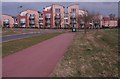
2
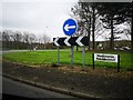
Milton Keynes : Medbourne Roundabout
Looking across the roundabout.
Image: © Lewis Clarke
Taken: 19 Mar 2019
0.11 miles
3
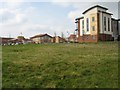
Christ the Sower
To the left Christ the Sower voluntary aided ecumnical school. To the left part of a mix of commercial and residential buildings on Dunthorne Way near 'Budgens' store at Newhill Place.
Image: © Malcolm Campbell
Taken: 17 Mar 2009
0.11 miles
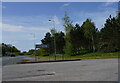
4
Looking across H5 Portway
Waiting at a road junction of Singleton Drive and H5 Portway.
Image: © Malcolm Neal
Taken: 19 Apr 2022
0.13 miles
5
H5 Portway
At the junction with Singleton Drive looking along H5 Portway.
Image: © Malcolm Neal
Taken: 19 Apr 2022
0.13 miles
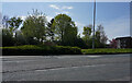
6
Redway view
Looking along redway toward recent housing development - Oldham Rise in Medbourne
Image: © Malcolm Campbell
Taken: 17 Mar 2009
0.15 miles
7
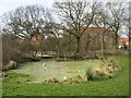
Pond life
Pond in the vicinity of Hoyton Gate and Ashford Crescent/Dunthorne Way. Shame about all of the litter and rubbish.
Image: © Malcolm Campbell
Taken: 17 Mar 2009
0.18 miles