IMAGES TAKEN NEAR TO
Cruickshank Grove, MILTON KEYNES, MK8 0EZ
Introduction
This page details the photographs taken nearby to Cruickshank Grove, MK8 0EZ by members of the Geograph project.
The Geograph project started in 2005 with the aim of publishing, organising and preserving representative images for every square kilometre of Great Britain, Ireland and the Isle of Man.

There are currently over 7.5m images from over14,400 individuals and you can help contribute to the project by visiting https://www.geograph.org.uk
Image Map
Images are licensed for reuse under creativecommons.org/licenses/by-sa/2.0
Notes
- Clicking on the map will re-center to the selected point.
- The higher the marker number, the further away the image location is from the centre of the postcode.
Image Listing (12 Images Found)
Images are licensed for reuse under creativecommons.org/licenses/by-sa/2.0
Image
Details
Distance

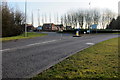
5
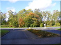
The entrance of Crownhill Crematorium
At the junction with Dansteed Way
Image: © Geographer
Taken: 18 Oct 2012
0.21 miles
6
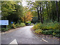
The entrance to Crownhill Crematorium
Off Dansteed Way
Image: © Geographer
Taken: 18 Oct 2012
0.21 miles
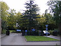
7
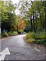
The entrance to Crownhill Crematorium
Off Dansteed Way
http://www.milton-keynes.gov.uk/bereavement-services/displayarticle.asp?ID=13558
Image: © Geographer
Taken: 18 Oct 2012
0.21 miles
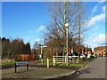
8
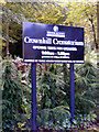
Crownhill Crematorium Sign
Off Dansteed Way
Image: © Geographer
Taken: 18 Oct 2012
0.21 miles
9
The entrance to Crownhill Crematorium
Off Dansteed Road
Image: © Geographer
Taken: 18 Oct 2012
0.21 miles