IMAGES TAKEN NEAR TO
Elgar Grove, MILTON KEYNES, MK7 8DX
Introduction
This page details the photographs taken nearby to Elgar Grove, MK7 8DX by members of the Geograph project.
The Geograph project started in 2005 with the aim of publishing, organising and preserving representative images for every square kilometre of Great Britain, Ireland and the Isle of Man.

There are currently over 7.5m images from over14,400 individuals and you can help contribute to the project by visiting https://www.geograph.org.uk
Image Map
Images are licensed for reuse under creativecommons.org/licenses/by-sa/2.0
Notes
- Clicking on the map will re-center to the selected point.
- The higher the marker number, the further away the image location is from the centre of the postcode.
Image Listing (11 Images Found)
Images are licensed for reuse under creativecommons.org/licenses/by-sa/2.0
Image
Details
Distance
2
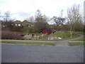
Pond, Old Farm Park
The Parks Trust maintains the linear parkland running through Old Farm Park including this small pond which lies beside Boyce Crescent and a footpath running at the rear of houses on Britten Grove.
Image: © Shirley Jones
Taken: 26 Feb 2010
0.15 miles
3
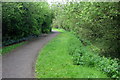
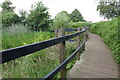
Footpath from Old Farm Park to Browns Wood
Running from Boyce Crescent at the rear of the Community Centre and small retail outlet linking the two housing developments of Old Farm Park and Browns Wood and beside a stream.
Image: © Shirley Jones
Taken: 26 Feb 2010
0.19 miles
5

Milton Keynes : Hockliffe Brae
A road heading off from Bletcham Way.
Image: © Lewis Clarke
Taken: 24 Mar 2018
0.21 miles
6
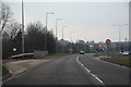
Milton Keynes : Bletcham Way A4146
Heading along the A4146 in Milton Keynes.
Image: © Lewis Clarke
Taken: 24 Mar 2018
0.22 miles
7
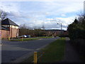
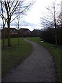
Holst Crescent, Old Farm Park
One end of the Crescent which lies closest to the small retail zone and adjoins Britten Grove. The storage unit to the shop can be seen on the left of the picture. The yellow post indicates a pavement junction with the redway system.
Image: © Shirley Jones
Taken: 26 Feb 2010
0.23 miles
8
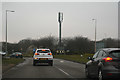
Milton Keynes : Bletcham Way A4146
Approaching Browns Wood Roundabout.
Image: © Lewis Clarke
Taken: 24 Mar 2018
0.23 miles
9
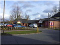
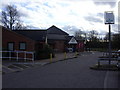
Retail outlet at Britten Grove community centre, Old Farm Park
In 2010 Tesco accommodates this shopping hub on the small estate that links Browns Wood and Old Farm Park in the south eastern corner of Milton Keynes. It lies on Britten Grove in an area where all streets are named after composers. This image pre-dates proposals to make the car park one way.
Image: © Shirley Jones
Taken: 26 Feb 2010
0.24 miles
10
Britten Grove Community Centre
The centre is home to a nursery, Baptist Church and lies on the same development as a small grocery retail outfit run by Tesco at the time of the photograph.
Image: © Shirley Jones
Taken: 26 Feb 2010
0.24 miles