IMAGES TAKEN NEAR TO
Saunders Close, MILTON KEYNES, MK7 7RS
Introduction
This page details the photographs taken nearby to Saunders Close, MK7 7RS by members of the Geograph project.
The Geograph project started in 2005 with the aim of publishing, organising and preserving representative images for every square kilometre of Great Britain, Ireland and the Isle of Man.

There are currently over 7.5m images from over14,400 individuals and you can help contribute to the project by visiting https://www.geograph.org.uk
Image Map
Images are licensed for reuse under creativecommons.org/licenses/by-sa/2.0
Notes
- Clicking on the map will re-center to the selected point.
- The higher the marker number, the further away the image location is from the centre of the postcode.
Image Listing (7 Images Found)
Images are licensed for reuse under creativecommons.org/licenses/by-sa/2.0
Image
Details
Distance
1
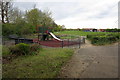
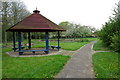
Playground on the edge of the cricket green
Image: © Philip Jeffrey
Taken: 6 May 2012
0.06 miles
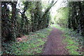
2
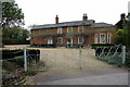
Passalewe Lane, Wavendon Gate
As the two riders might suggest, this is close to the rural edge of Milton Keynes. The horses are following a horse ride between the lane and the recreation area on the left.
Image: © Derek Harper
Taken: 5 Feb 2011
0.07 miles
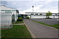
7
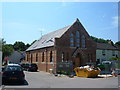
Converted Methodist Chapel, Wavendon
This chapel seems to have only recently been converted into someone's home. The property is a traditionally constructed chapel located on the junction of Walton Road and Phoebe Lane.
Image: © Mr Biz
Taken: 8 Jun 2008
0.25 miles