IMAGES TAKEN NEAR TO
Katherine Close, MILTON KEYNES, MK7 7JH
Introduction
This page details the photographs taken nearby to Katherine Close, MK7 7JH by members of the Geograph project.
The Geograph project started in 2005 with the aim of publishing, organising and preserving representative images for every square kilometre of Great Britain, Ireland and the Isle of Man.

There are currently over 7.5m images from over14,400 individuals and you can help contribute to the project by visiting https://www.geograph.org.uk
Image Map
Images are licensed for reuse under creativecommons.org/licenses/by-sa/2.0
Notes
- Clicking on the map will re-center to the selected point.
- The higher the marker number, the further away the image location is from the centre of the postcode.
Image Listing (8 Images Found)
Images are licensed for reuse under creativecommons.org/licenses/by-sa/2.0
Image
Details
Distance
4
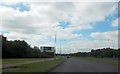
Entrance to Water Sports Centre from Bletcham Way
Image: © John Firth
Taken: 22 Sep 2013
0.19 miles
8
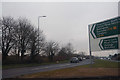
Milton Keynes : Bletcham Way A4146
A road heading off from Walton Park Roundabout.
Image: © Lewis Clarke
Taken: 24 Mar 2018
0.25 miles