IMAGES TAKEN NEAR TO
Huckleberry Close, MILTON KEYNES, MK7 7ER
Introduction
This page details the photographs taken nearby to Huckleberry Close, MK7 7ER by members of the Geograph project.
The Geograph project started in 2005 with the aim of publishing, organising and preserving representative images for every square kilometre of Great Britain, Ireland and the Isle of Man.

There are currently over 7.5m images from over14,400 individuals and you can help contribute to the project by visiting https://www.geograph.org.uk
Image Map
Images are licensed for reuse under creativecommons.org/licenses/by-sa/2.0
Notes
- Clicking on the map will re-center to the selected point.
- The higher the marker number, the further away the image location is from the centre of the postcode.
Image Listing (9 Images Found)
Images are licensed for reuse under creativecommons.org/licenses/by-sa/2.0
Image
Details
Distance
1
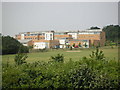
Walton High School
A view of the rear of Walton High School and sports fields from Browns Wood roundabout.
Image: © Mr Biz
Taken: 26 Jul 2006
0.07 miles
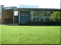
3
The Tawny Owl, Milton Keynes
The modern pub is at Fyfield Barrow. Seen here across Tongwell Street.
Image: © Derek Harper
Taken: 5 Feb 2011
0.19 miles
5
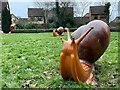
Snails in the park at Walnut Tree
They've painted them since I was last here Image
Image: © Philip Jeffrey
Taken: 23 Jan 2022
0.20 miles
6
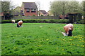
Green space by the local playground in Walnut Tree
With grazing snails
Image: © Philip Jeffrey
Taken: 23 Apr 2012
0.20 miles
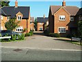
7
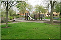
Playground by the Redway in Walnut Tree
Image: © Philip Jeffrey
Taken: 23 Apr 2012
0.23 miles
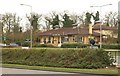
9
Milton Keynes : Hockliffe Brae
A road heading off from Bletcham Way.
Image: © Lewis Clarke
Taken: 24 Mar 2018
0.24 miles