IMAGES TAKEN NEAR TO
Tenterden Crescent, MILTON KEYNES, MK7 6HH
Introduction
This page details the photographs taken nearby to Tenterden Crescent, MK7 6HH by members of the Geograph project.
The Geograph project started in 2005 with the aim of publishing, organising and preserving representative images for every square kilometre of Great Britain, Ireland and the Isle of Man.

There are currently over 7.5m images from over14,400 individuals and you can help contribute to the project by visiting https://www.geograph.org.uk
Image Map
Images are licensed for reuse under creativecommons.org/licenses/by-sa/2.0
Notes
- Clicking on the map will re-center to the selected point.
- The higher the marker number, the further away the image location is from the centre of the postcode.
Image Listing (7 Images Found)
Images are licensed for reuse under creativecommons.org/licenses/by-sa/2.0
Image
Details
Distance
1
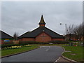
Church of Christ the King, Kents Hill
Also serves as the local community centre.
Image: © Mr Biz
Taken: 20 Mar 2008
0.06 miles
2
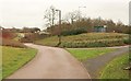
Path, Kents Hill
The path running parallel to Groveway passes a bus stop and dips to meet and cross Birdlip Lane.
Image: © Derek Harper
Taken: 5 Feb 2011
0.09 miles
3
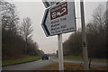
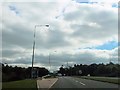
Milton Keynes : Groveway
From Walnut Tree Roundabout looking along Groveway.
Image: © Lewis Clarke
Taken: 24 Mar 2018
0.19 miles
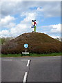
5
Tongwell Street bus stop by Walnut Tree roundabout
Image: © John Firth
Taken: 22 Sep 2013
0.23 miles
6
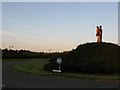
Two People Standing Back to Back in Milton Keynes
The Timbold Drive roundabout, Kents Hill, Milton Keynes. The roundabout is on the edge of the Open University campus, near the Hilton Hotel and on the road to the Accenture Centre.
Image: © Duncan David McColl
Taken: 26 Sep 2008
0.23 miles
7
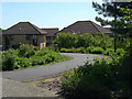
Juniper Gardens, Walnut Tree, Milton Keynes
Image: © Cameraman
Taken: 16 Jun 2010
0.24 miles