IMAGES TAKEN NEAR TO
Lloyds, MILTON KEYNES, MK6 5EB
Introduction
This page details the photographs taken nearby to Lloyds, MK6 5EB by members of the Geograph project.
The Geograph project started in 2005 with the aim of publishing, organising and preserving representative images for every square kilometre of Great Britain, Ireland and the Isle of Man.

There are currently over 7.5m images from over14,400 individuals and you can help contribute to the project by visiting https://www.geograph.org.uk
Image Map
Images are licensed for reuse under creativecommons.org/licenses/by-sa/2.0
Notes
- Clicking on the map will re-center to the selected point.
- The higher the marker number, the further away the image location is from the centre of the postcode.
Image Listing (5 Images Found)
Images are licensed for reuse under creativecommons.org/licenses/by-sa/2.0
Image
Details
Distance
3
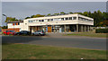
Grigby Rise, Coffee Hall, Milton Keynes
Taken from the junction with Lloyds.
Image: © Cameraman
Taken: 2 Oct 2009
0.04 miles
4
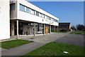
Lloyds, Coffee Hall, Milton Keynes
This is one of the two estate link roads, one each end of the residential roads.
Image: © Cameraman
Taken: 2 Oct 2009
0.05 miles
5
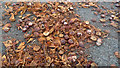
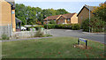
Conkers, still where they fell
A few years ago, local kids would have collected every conker they could find. Now they are left to rot, or get squashed by cars.
Image: © Cameraman
Taken: 12 Oct 2009
0.23 miles