IMAGES TAKEN NEAR TO
Medale Road, MILTON KEYNES, MK6 4NA
Introduction
This page details the photographs taken nearby to Medale Road, MK6 4NA by members of the Geograph project.
The Geograph project started in 2005 with the aim of publishing, organising and preserving representative images for every square kilometre of Great Britain, Ireland and the Isle of Man.

There are currently over 7.5m images from over14,400 individuals and you can help contribute to the project by visiting https://www.geograph.org.uk
Image Map
Images are licensed for reuse under creativecommons.org/licenses/by-sa/2.0
Notes
- Clicking on the map will re-center to the selected point.
- The higher the marker number, the further away the image location is from the centre of the postcode.
Image Listing (32 Images Found)
Images are licensed for reuse under creativecommons.org/licenses/by-sa/2.0
Image
Details
Distance
1
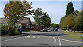
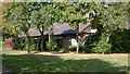
Medale Road, Beanhill, Milton Keynes.
Taken from the junction with Neapland, the photo shows phase two brick built bungalows along the left-hand side of Medale Road.
Image: © Cameraman
Taken: 24 Sep 2009
0.03 miles
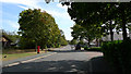
2
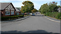
Medale Road, Beanhill, Milton Keynes
Looking up Medale Road towards Standing Way from the junction with Neapland.
Image: © Cameraman
Taken: 24 Sep 2009
0.04 miles
3
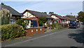
Woodrush Close, Beanhill, Milton Keynes.
Woodrush Close, typical phase two housing and close.
Image: © Cameraman
Taken: 24 Sep 2009
0.09 miles
4
Medale Road, Beanhill, Milton Keynes.
Taken from the top of Medale Road looking towards Beanfare.
Image: © Cameraman
Taken: 24 Sep 2009
0.09 miles
5
Bungalow, Beanhill, Milton Keynes.
The side/rear view of the end bungalow in Woodrush Close.
Image: © Cameraman
Taken: 24 Sep 2009
0.11 miles
6
Medale Road, Beanhill, Milton Keynes.
Looking up almost the full length of Medale Road from Beanfare towards Standing Way.
Image: © Cameraman
Taken: 24 Sep 2009
0.11 miles
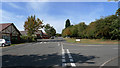
7
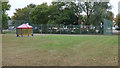
Play Area in Beanhill
Showing the basket ball/tennis court and the teanager's shelter.
Image: © Cameraman
Taken: 5 Oct 2009
0.11 miles
8
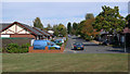
Beanfare, Beanhill, Milton Keynes.
Looking along Beanfare, the junction with Medale Road is half way along and on the left.
Image: © Cameraman
Taken: 24 Sep 2009
0.11 miles
9
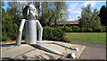
From the 'Wizard of Oz', the Tin Man at Beanhill.
In 1978/79 a character, the Tin-Man from the story Wizard of Oz, was sited in Beanhill. This community project was organised by Liz Leyh, resident artist for Milton Keynes Development Corporation. Other artists, Lesley Bonner and Michael Grabowski, were involved in the completion of the project.
Image: © Cameraman
Taken: 10 Sep 2009
0.12 miles
10
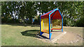
Shelter at Beanhill, Milton Keynes
Erected on one of the open spaces, close to a tennis/basketball area, as a meeting place for the teenagers of the estate. In the background can be seen a playground for younger children.
Image: © Cameraman
Taken: 24 Sep 2009
0.12 miles