IMAGES TAKEN NEAR TO
Wetheringsett, MILTON KEYNES, MK6 4AY
Introduction
This page details the photographs taken nearby to Wetheringsett, MK6 4AY by members of the Geograph project.
The Geograph project started in 2005 with the aim of publishing, organising and preserving representative images for every square kilometre of Great Britain, Ireland and the Isle of Man.

There are currently over 7.5m images from over14,400 individuals and you can help contribute to the project by visiting https://www.geograph.org.uk
Image Map
Images are licensed for reuse under creativecommons.org/licenses/by-sa/2.0
Notes
- Clicking on the map will re-center to the selected point.
- The higher the marker number, the further away the image location is from the centre of the postcode.
Image Listing (18 Images Found)
Images are licensed for reuse under creativecommons.org/licenses/by-sa/2.0
Image
Details
Distance
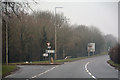
1
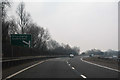
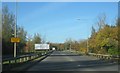
Milton Keynes : The A5
A road heading through Milton Keynes.
Image: © Lewis Clarke
Taken: 25 Mar 2018
0.10 miles

4
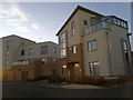
The Showhouse at Ashland
Complete with advertising banner.
Image: © Cameraman
Taken: 17 May 2010
0.12 miles
5
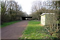
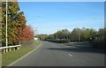
Groveway - Milton Keynes
Running between Netherfield and Ashland.
Image: © Mr Ignavy
Taken: 28 Oct 2011
0.12 miles
6
Saxon Street
Approach to junction with Groveway.
Image: © Mr Ignavy
Taken: 28 Oct 2011
0.13 miles
8
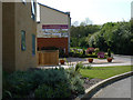
24 Flexerne Crescent, Milton Keynes
Number 24 Flexerne Crescent is an ultra-modern house in the Ashland area of Milton Keynes, in Buckinghamshire, England.
Image: © Steven Haslington
Taken: 19 Feb 2012
0.13 miles
10
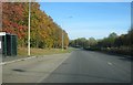
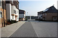
Milton Keynes : Groveway
Heading along Groveway.
Image: © Lewis Clarke
Taken: 25 Mar 2018
0.20 miles