IMAGES TAKEN NEAR TO
Turnmill Avenue, MILTON KEYNES, MK6 3HU
Introduction
This page details the photographs taken nearby to Turnmill Avenue, MK6 3HU by members of the Geograph project.
The Geograph project started in 2005 with the aim of publishing, organising and preserving representative images for every square kilometre of Great Britain, Ireland and the Isle of Man.

There are currently over 7.5m images from over14,400 individuals and you can help contribute to the project by visiting https://www.geograph.org.uk
Image Map
Images are licensed for reuse under creativecommons.org/licenses/by-sa/2.0
Notes
- Clicking on the map will re-center to the selected point.
- The higher the marker number, the further away the image location is from the centre of the postcode.
Image Listing (53 Images Found)
Images are licensed for reuse under creativecommons.org/licenses/by-sa/2.0
Image
Details
Distance
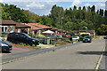
1
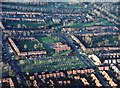
Shepherdswell First School, Springfield
Shepherdswell First School in Springfield, Milton Keynes. Aerial photo taken from a height of around 1500ft above ground level.
Image: © Mike Belch
Taken: 19 Nov 2000
0.03 miles
10
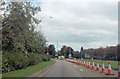
Approaching South Overgate roundabout from Childs Way
Image: © John Firth
Taken: 22 Sep 2013
0.19 miles