IMAGES TAKEN NEAR TO
Verity Place, MILTON KEYNES, MK6 2QF
Introduction
This page details the photographs taken nearby to Verity Place, MK6 2QF by members of the Geograph project.
The Geograph project started in 2005 with the aim of publishing, organising and preserving representative images for every square kilometre of Great Britain, Ireland and the Isle of Man.

There are currently over 7.5m images from over14,400 individuals and you can help contribute to the project by visiting https://www.geograph.org.uk
Image Map
Images are licensed for reuse under creativecommons.org/licenses/by-sa/2.0
Notes
- Clicking on the map will re-center to the selected point.
- The higher the marker number, the further away the image location is from the centre of the postcode.
Image Listing (5 Images Found)
Images are licensed for reuse under creativecommons.org/licenses/by-sa/2.0
Image
Details
Distance
3
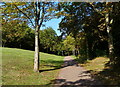
Path and cycle track in Central Milton Keynes
Image: © Mat Fascione
Taken: 8 Aug 2015
0.19 miles
4
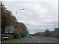
Approaching South Saxon roundabout from Childs Way
Image: © John Firth
Taken: 22 Sep 2013
0.21 miles