IMAGES TAKEN NEAR TO
Tolcarne Avenue, MILTON KEYNES, MK6 2BZ
Introduction
This page details the photographs taken nearby to Tolcarne Avenue, MK6 2BZ by members of the Geograph project.
The Geograph project started in 2005 with the aim of publishing, organising and preserving representative images for every square kilometre of Great Britain, Ireland and the Isle of Man.

There are currently over 7.5m images from over14,400 individuals and you can help contribute to the project by visiting https://www.geograph.org.uk
Image Map
Images are licensed for reuse under creativecommons.org/licenses/by-sa/2.0
Notes
- Clicking on the map will re-center to the selected point.
- The higher the marker number, the further away the image location is from the centre of the postcode.
Image Listing (21 Images Found)
Images are licensed for reuse under creativecommons.org/licenses/by-sa/2.0
Image
Details
Distance
1
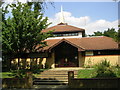
Seventh Day Adventist Church, Fishermead
What I believe to be Milton Keynes' only Seventh Day Adventist church.
Image: © Mr Biz
Taken: 25 Jul 2006
0.06 miles
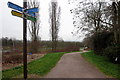
3
Looking Right from Mullion Place to Tolcarne Avenue
Image: © Cameraman
Taken: 10 Dec 2009
0.11 miles

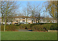
5
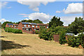
Green (or not so green) space on the edge of Springfield
Showing signs of what seems set to be a record-breaking dry summer.
Image: © David Martin
Taken: 5 Aug 2022
0.15 miles
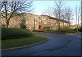
6
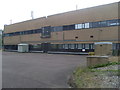
Telephone Exchange, Fishermead (1)
Situated at the South end of Helford Place, this modern TE serves Central Milton Keynes, plus Coffee Hall, Eaglestone, Fishermead, Netherfield, Oldbrook and Springfield in Milton Keynes. It is the area covered by the MK6 and MK9 postcodes. This photo shows a grey generator, a BT warning notice on the front of the building and a yellow grit salt bin, useful when the parking area in front of it is icy.
Image: © David Hillas
Taken: 20 Sep 2014
0.19 miles
7

Telephone Exchange, Fishermead (2)
This TE which is situated in Helford Place MK6 2SY, rather resembles a modern office block and used to take the name Bradwell Abbey, a priory which dates from the mid-12th Century. That abbey is now an Urban Studies Centre, SP8239 refers, and is ironically served by Wolverton TE, SP8141 refers. A mobile phone aerial can be seen on the roof of this building.
Image: © David Hillas
Taken: 20 Sep 2014
0.19 miles
8
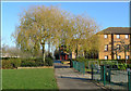
View Towards Mullion Place
From Fishermead Play Area.
Image: © Cameraman
Taken: 10 Dec 2009
0.19 miles
9
The Junction of Fishermead Boulevard and Pencarrow Place
Image: © Cameraman
Taken: 10 Dec 2009
0.19 miles
10
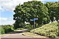
Pathways below roundabout at southern corner of Springfield
Image: © David Martin
Taken: 5 Aug 2022
0.21 miles