IMAGES TAKEN NEAR TO
Snowdon Drive, MILTON KEYNES, MK6 1AP
Introduction
This page details the photographs taken nearby to Snowdon Drive, MK6 1AP by members of the Geograph project.
The Geograph project started in 2005 with the aim of publishing, organising and preserving representative images for every square kilometre of Great Britain, Ireland and the Isle of Man.

There are currently over 7.5m images from over14,400 individuals and you can help contribute to the project by visiting https://www.geograph.org.uk
Image Map (Loading...)


Getting Data...Please wait
Leaflet Map data © OpenStreetMap
Images are licensed for reuse under creativecommons.org/licenses/by-sa/2.0
Notes
- Clicking on the map will re-center to the selected point.
- The higher the marker number, the further away the image location is from the centre of the postcode.
Image Listing (31 Images Found)
Images are licensed for reuse under creativecommons.org/licenses/by-sa/2.0
Image
Details
Distance
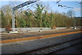
4
Signalling Solutions by the West Coast Main Line
Image: © N Chadwick
Taken: 19 Dec 2010
0.11 miles
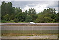
6
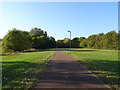
National Cycle Route 51, Loughton Valley Park
Image: © JThomas
Taken: 21 Sep 2019
0.13 miles
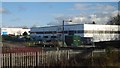
7
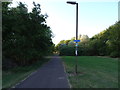
National Cycle Route 51, Loughton Valley Park
Image: © JThomas
Taken: 21 Sep 2019
0.13 miles