IMAGES TAKEN NEAR TO
Little Meadow, MILTON KEYNES, MK5 8EH
Introduction
This page details the photographs taken nearby to Little Meadow, MK5 8EH by members of the Geograph project.
The Geograph project started in 2005 with the aim of publishing, organising and preserving representative images for every square kilometre of Great Britain, Ireland and the Isle of Man.

There are currently over 7.5m images from over14,400 individuals and you can help contribute to the project by visiting https://www.geograph.org.uk
Image Map
Images are licensed for reuse under creativecommons.org/licenses/by-sa/2.0
Notes
- Clicking on the map will re-center to the selected point.
- The higher the marker number, the further away the image location is from the centre of the postcode.
Image Listing (20 Images Found)
Images are licensed for reuse under creativecommons.org/licenses/by-sa/2.0
Image
Details
Distance
1
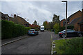
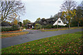
Little Meadow Milton Keynes
A fairly new housing estate of houses that are more expensive than the national average.
Image: © Malcolm Neal
Taken: 16 Oct 2020
0.01 miles
2
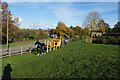
The horse themed climbing frame
This is one of the children's toys in the small playground near Ashpole Furlong.
Image: © Malcolm Neal
Taken: 30 Oct 2021
0.06 miles
3
Near the equestrian centre
Looking down the hill towards the equestrian centre called Loughton Equestrian Centre on the map but the signs around the centre give the name Ride High Equestrian Centre.
Image: © Malcolm Neal
Taken: 1 Nov 2020
0.06 miles
4
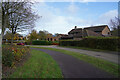
Little Meadow Milton Keynes
A housing estate of fairly modern houses that cost rather more than the national average.
Image: © Malcolm Neal
Taken: 16 Oct 2020
0.06 miles
5
A large house in Loughton
This began as a large house but it has also been extensively extended so is now a very large suburban house.
Image: © Malcolm Neal
Taken: 1 Nov 2020
0.08 miles
6
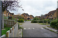
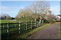
The road to the centre
This road runs towards the Ride High Equestrian Centre and passes by some very large modern houses.
Image: © Malcolm Neal
Taken: 1 Nov 2020
0.08 miles
7
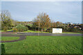
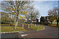
Looking across Ashpole Furlong
Standing in the small children's playground looking across the appropriately named road near the equestrian centre.
Image: © Malcolm Neal
Taken: 30 Oct 2021
0.09 miles
8
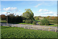
Redland Drive
This is the wide pavement alongside Redland Drive, looking over the fence to what may be part of the equestrian centre.
Image: © Malcolm Neal
Taken: 1 Nov 2020
0.09 miles
9
Near the underpass
The road is Ashpole Furlong and it joins Childs Way to the right, though the footpath diverts to an underpass which leads to a suburban park.
Image: © Malcolm Neal
Taken: 1 Nov 2020
0.10 miles
10

Looking across Childs Way
Childs Way is a typical Milton Keynes road which has many road junctions that all have a roundabout at the junction.
Image: © Malcolm Neal
Taken: 1 Nov 2020
0.10 miles