IMAGES TAKEN NEAR TO
Cottage Common, MILTON KEYNES, MK5 8AE
Introduction
This page details the photographs taken nearby to Cottage Common, MK5 8AE by members of the Geograph project.
The Geograph project started in 2005 with the aim of publishing, organising and preserving representative images for every square kilometre of Great Britain, Ireland and the Isle of Man.

There are currently over 7.5m images from over14,400 individuals and you can help contribute to the project by visiting https://www.geograph.org.uk
Image Map
Images are licensed for reuse under creativecommons.org/licenses/by-sa/2.0
Notes
- Clicking on the map will re-center to the selected point.
- The higher the marker number, the further away the image location is from the centre of the postcode.
Image Listing (151 Images Found)
Images are licensed for reuse under creativecommons.org/licenses/by-sa/2.0
Image
Details
Distance
1
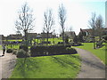
Somewhere to rest and play
Children's play area, landscaped gardens and grassy area in front of new housing in the Loughton area of Milton Keynes.
Image: © Martin Addison
Taken: 5 Apr 2006
0.02 miles
2

Pitcher Lane, Loughton
Pitcher Lane forms part of Loughton village, a settlement absorbed into Milton Keynes but retaining a rural feel.
Image: © Stephen McKay
Taken: 10 Sep 2015
0.05 miles
3
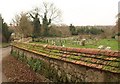
Graveyard wall, Loughton
With a neatly tiled coping to the top. This graveyard is southeast of the church, a little away from the immediate churchyard.
Image: © Derek Harper
Taken: 4 Feb 2011
0.06 miles
4
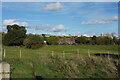
Distant development
Looking across the fields next to Whitworth Lane towards the distant tower cranes.
Image: © Malcolm Neal
Taken: 30 Oct 2021
0.09 miles
5
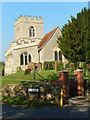
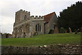
Loughton Church
All Saints' Church stands at the heart of the old village of Loughton, now very much a part of Milton Keynes although it has retained its rural character. The church dates from the 13th century with later extensions; it was restored twice in the 19th century.
Image: © Stephen McKay
Taken: 10 Sep 2015
0.10 miles
7
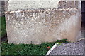
Benchmark on porch of All Saints Church
Ordnance Survey cut mark benchmark described on the Bench Mark Database at http://www.bench-marks.org.uk/bm79887
Image: © Roger Templeman
Taken: 20 Oct 2016
0.10 miles
8
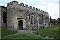
South face of All Saints Church
There is an OS benchmark Image on the base stone of the left hand side of the porch
Image: © Roger Templeman
Taken: 20 Oct 2016
0.10 miles
9
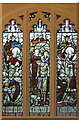
All Saints, Loughton - Stained glass window
Image: © John Salmon
Taken: 10 Sep 2016
0.11 miles
10
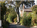
School Lane, Loughton
Although surrounded by new development, Loughton has retained its bucolic charm as this view from close to the church illustrates. There has been a conscious effort to maintain the character of older settlements within Milton Keynes.
Image: © Stephen McKay
Taken: 10 Sep 2015
0.11 miles