IMAGES TAKEN NEAR TO
Orpington Grove, MILTON KEYNES, MK5 7HL
Introduction
This page details the photographs taken nearby to Orpington Grove, MK5 7HL by members of the Geograph project.
The Geograph project started in 2005 with the aim of publishing, organising and preserving representative images for every square kilometre of Great Britain, Ireland and the Isle of Man.

There are currently over 7.5m images from over14,400 individuals and you can help contribute to the project by visiting https://www.geograph.org.uk
Image Map
Images are licensed for reuse under creativecommons.org/licenses/by-sa/2.0
Notes
- Clicking on the map will re-center to the selected point.
- The higher the marker number, the further away the image location is from the centre of the postcode.
Image Listing (18 Images Found)
Images are licensed for reuse under creativecommons.org/licenses/by-sa/2.0
Image
Details
Distance
1
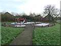
Too cold to play
Frost playpark at Cressey Avenue.
Image: © Malcolm Campbell
Taken: 13 Jan 2012
0.05 miles
2
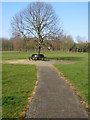
Circular bench in Shenley Brook End Park
Image: © Philip Jeffrey
Taken: 1 Mar 2012
0.10 miles
5
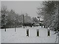
Rosecomb Place
Snowed heavily overnight leaving us all looking for something useful to do except work or try and get to work. The three wooden posts block vehicular access down Rosecomb Place off the red route.
Image: © Malcolm Campbell
Taken: 5 Feb 2009
0.18 miles
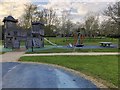
6
Shenley Brooke End-Cressey Avenue
At the junction with Wallinger Drive.
Image: © Ian Rob
Taken: 17 Feb 2017
0.19 miles
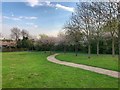
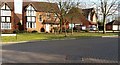
7

Bremen Grove
A cul-de-sac of modern houses in Shenley Brook End, another of the Milton Keynes suburbs.
Image: © Malcolm Neal
Taken: 19 Apr 2022
0.20 miles
8
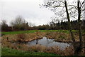
Pond by the path under Fulmar Street (with Heron)
Image: © Philip Jeffrey
Taken: 17 Mar 2012
0.21 miles
9
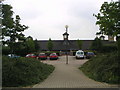
Caroline Haslett Combined School
Located on Shenley Lodge, the school is identifiable by its 5 glassed lookout towers. The school's crest also features one of the lookout towers.
Image: © Mr Biz
Taken: 27 Jul 2006
0.22 miles
10
Dried up
This old moat has really dried up during 2011. Normally full of water at this time of the year - another example of climate change.
Image: © Malcolm Campbell
Taken: 16 Nov 2011
0.22 miles