IMAGES TAKEN NEAR TO
Copes Haven, MILTON KEYNES, MK5 7HA
Introduction
This page details the photographs taken nearby to Copes Haven, MK5 7HA by members of the Geograph project.
The Geograph project started in 2005 with the aim of publishing, organising and preserving representative images for every square kilometre of Great Britain, Ireland and the Isle of Man.

There are currently over 7.5m images from over14,400 individuals and you can help contribute to the project by visiting https://www.geograph.org.uk
Image Map (Loading...)


Getting Data...Please wait
Leaflet Map data © OpenStreetMap
Images are licensed for reuse under creativecommons.org/licenses/by-sa/2.0
Notes
- Clicking on the map will re-center to the selected point.
- The higher the marker number, the further away the image location is from the centre of the postcode.
Image Listing (9 Images Found)
Images are licensed for reuse under creativecommons.org/licenses/by-sa/2.0
Image
Details
Distance
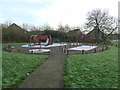
1
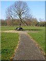
Circular bench in Shenley Brook End Park
Image: © Philip Jeffrey
Taken: 1 Mar 2012
0.07 miles
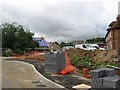
2
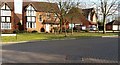
Shenley Brooke End-Cressey Avenue
At the junction with Wallinger Drive.
Image: © Ian Rob
Taken: 17 Feb 2017
0.13 miles
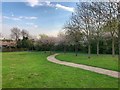
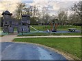
5
Too cold to play
Frost playpark at Cressey Avenue.
Image: © Malcolm Campbell
Taken: 13 Jan 2012
0.18 miles
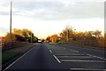
7

Approaching a roundabout on Chaffron Way
Image: © Steve Daniels
Taken: 3 Nov 2014
0.22 miles
9
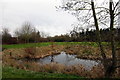
Pond by the path under Fulmar Street (with Heron)
Image: © Philip Jeffrey
Taken: 17 Mar 2012
0.23 miles