IMAGES TAKEN NEAR TO
Sebright Close, MILTON KEYNES, MK5 7GW
Introduction
This page details the photographs taken nearby to Sebright Close, MK5 7GW by members of the Geograph project.
The Geograph project started in 2005 with the aim of publishing, organising and preserving representative images for every square kilometre of Great Britain, Ireland and the Isle of Man.

There are currently over 7.5m images from over14,400 individuals and you can help contribute to the project by visiting https://www.geograph.org.uk
Image Map
Images are licensed for reuse under creativecommons.org/licenses/by-sa/2.0
Notes
- Clicking on the map will re-center to the selected point.
- The higher the marker number, the further away the image location is from the centre of the postcode.
Image Listing (9 Images Found)
Images are licensed for reuse under creativecommons.org/licenses/by-sa/2.0
Image
Details
Distance
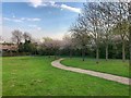
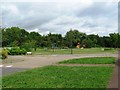
3
Circular bench in Shenley Brook End Park
Image: © Philip Jeffrey
Taken: 1 Mar 2012
0.13 miles
6
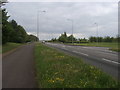
Childs Way
Childs Way passing Wildacre Road turning to Shenley Wood
Image: © Shaun Ferguson
Taken: 2 May 2014
0.21 miles
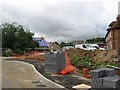
7

Bremen Grove
A cul-de-sac of modern houses in Shenley Brook End, another of the Milton Keynes suburbs.
Image: © Malcolm Neal
Taken: 19 Apr 2022
0.21 miles
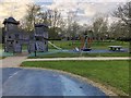
8
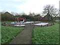
Too cold to play
Frost playpark at Cressey Avenue.
Image: © Malcolm Campbell
Taken: 13 Jan 2012
0.23 miles
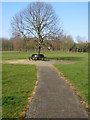
9
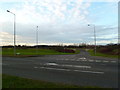
Wildacre Road
Looking along Wildacre Road from the 'redway' at the junction with Childs Way.
Image: © Malcolm Campbell
Taken: 24 Dec 2011
0.24 miles