IMAGES TAKEN NEAR TO
Harlequin Place, MILTON KEYNES, MK5 7FF
Introduction
This page details the photographs taken nearby to Harlequin Place, MK5 7FF by members of the Geograph project.
The Geograph project started in 2005 with the aim of publishing, organising and preserving representative images for every square kilometre of Great Britain, Ireland and the Isle of Man.

There are currently over 7.5m images from over14,400 individuals and you can help contribute to the project by visiting https://www.geograph.org.uk
Image Map
Images are licensed for reuse under creativecommons.org/licenses/by-sa/2.0
Notes
- Clicking on the map will re-center to the selected point.
- The higher the marker number, the further away the image location is from the centre of the postcode.
Image Listing (8 Images Found)
Images are licensed for reuse under creativecommons.org/licenses/by-sa/2.0
Image
Details
Distance
1
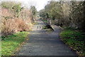
Path by Shenley Brook End allotments
This bridleway was one of the local roads before Milton Keynes srrived
Image: © Philip Jeffrey
Taken: 1 Mar 2012
0.10 miles
2
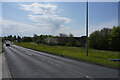
Tattenhoe Street
This is V2 Tattenhoe Street. The main roads in Milton Keynes seem to have a prefix H or V followed by a single digit.
Image: © Malcolm Neal
Taken: 19 Apr 2022
0.11 miles
4
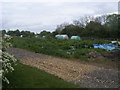
Powis Lane allotments
Off Childs Way the Powis Lane allotments
Image: © Shaun Ferguson
Taken: 2 May 2014
0.20 miles

6
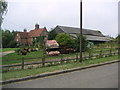
Westbury Farm
Showing off some rather interesting garden art, this is a view of the Westbury Farm site from Foxcovert Road
Image: © Mr Biz
Taken: 27 Jul 2006
0.23 miles
7
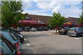
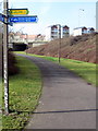
Pet Stores, Westcroft, Milton Keynes
Westcroft Retail Park is one of the larger 'out of town' shopping centres within Milton Keynes.
Image: © Cameraman
Taken: 25 Jul 2010
0.24 miles
8
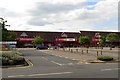
Retail outlets in the Westcroft District Centre
Image: © Steve Daniels
Taken: 13 Jul 2014
0.24 miles