IMAGES TAKEN NEAR TO
Northcroft, MILTON KEYNES, MK5 7BJ
Introduction
This page details the photographs taken nearby to Northcroft, MK5 7BJ by members of the Geograph project.
The Geograph project started in 2005 with the aim of publishing, organising and preserving representative images for every square kilometre of Great Britain, Ireland and the Isle of Man.

There are currently over 7.5m images from over14,400 individuals and you can help contribute to the project by visiting https://www.geograph.org.uk
Image Map
Images are licensed for reuse under creativecommons.org/licenses/by-sa/2.0
Notes
- Clicking on the map will re-center to the selected point.
- The higher the marker number, the further away the image location is from the centre of the postcode.
Image Listing (8 Images Found)
Images are licensed for reuse under creativecommons.org/licenses/by-sa/2.0
Image
Details
Distance
1
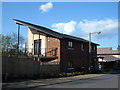
New Homes, Shenley Lodge, Milton Keynes
One of two new builds on Shenley Lodge using part brick, part timber construction.
Image: © Mr Biz
Taken: 23 Apr 2008
0.05 miles
2
New Homes, Shenley Lodge, Milton Keynes
Second of two part brick, part timber new builds on Shenley Lodge.
Image: © Mr Biz
Taken: 23 Apr 2008
0.06 miles
3
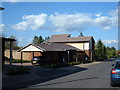
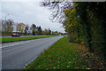
Milton Keynes : Knowlhill Roundabout
Approaching the roundabout from Childs Way.
Image: © Lewis Clarke
Taken: 19 Mar 2019
0.12 miles
4

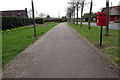
Swan's Way
Swan's Way in between Child's Way and Selby Grove.
Image: © Shaun Ferguson
Taken: 2 May 2014
0.17 miles
5

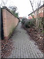
Trevithick Lane
In dappled light we walk to the Old Barn for lunch.
Image: © Malcolm Neal
Taken: 16 Oct 2022
0.18 miles
7
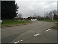
Looking across Childs Way
Childs Way is a typical Milton Keynes road which has many road junctions that all have a roundabout at the junction.
Image: © Malcolm Neal
Taken: 1 Nov 2020
0.20 miles