IMAGES TAKEN NEAR TO
Beddoes Croft, MILTON KEYNES, MK5 6FQ
Introduction
This page details the photographs taken nearby to Beddoes Croft, MK5 6FQ by members of the Geograph project.
The Geograph project started in 2005 with the aim of publishing, organising and preserving representative images for every square kilometre of Great Britain, Ireland and the Isle of Man.

There are currently over 7.5m images from over14,400 individuals and you can help contribute to the project by visiting https://www.geograph.org.uk
Image Map
Images are licensed for reuse under creativecommons.org/licenses/by-sa/2.0
Notes
- Clicking on the map will re-center to the selected point.
- The higher the marker number, the further away the image location is from the centre of the postcode.
Image Listing (6 Images Found)
Images are licensed for reuse under creativecommons.org/licenses/by-sa/2.0
Image
Details
Distance
2

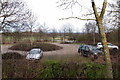
HMP Woodhill Visitors' Centre
The visitors' centre at the front of Woodhill Prison. Not sure if I was allowed to photo this or not!
Image: © Mr Biz
Taken: 27 Jul 2006
0.15 miles

5

Otterburn Crescent
These three storey buildings all look as though they are blocks of flats. They seem just too large for single houses!
Image: © Malcolm Neal
Taken: 19 Apr 2022
0.23 miles
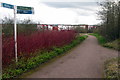
6
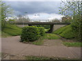
Swan's Way
Swan's Way heads under Tattenhoe Street
Image: © Shaun Ferguson
Taken: 2 May 2014
0.24 miles