IMAGES TAKEN NEAR TO
Knapp Gate, MILTON KEYNES, MK5 6DY
Introduction
This page details the photographs taken nearby to Knapp Gate, MK5 6DY by members of the Geograph project.
The Geograph project started in 2005 with the aim of publishing, organising and preserving representative images for every square kilometre of Great Britain, Ireland and the Isle of Man.

There are currently over 7.5m images from over14,400 individuals and you can help contribute to the project by visiting https://www.geograph.org.uk
Image Map (Loading...)


Getting Data...Please wait
Leaflet Map data © OpenStreetMap
Images are licensed for reuse under creativecommons.org/licenses/by-sa/2.0
Notes
- Clicking on the map will re-center to the selected point.
- The higher the marker number, the further away the image location is from the centre of the postcode.
Image Listing (21 Images Found)
Images are licensed for reuse under creativecommons.org/licenses/by-sa/2.0
Image
Details
Distance
2
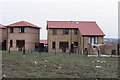
Newly-built houses, Lowndes Grove, Shenley Church End, 1989
Image: © Christopher Hilton
Taken: 18 Mar 1989
0.12 miles

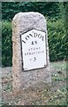
4
Milestone
Old milestone on what was the A.5 near to Loughton, Milton Keynes. For close up view see http://www.geograph.org.uk/photo/5381064
Image: © Keith Evans
Taken: 22 Apr 2017
0.14 miles
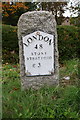
5
Old Milestone
Old milestone on what was the A.5 near to Loughton, Milton Keynes. For overall view see http://www.geograph.org.uk/photo/5381080
Image: © Keith Evans
Taken: 22 Apr 2017
0.16 miles
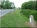
6

Gate A
Gate A of the factory SMC Pneumatics.
Image: © Malcolm Neal
Taken: 19 Apr 2022
0.16 miles
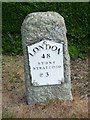
7
Old Milestone by the former A5 in Loughton, Milton Keynes
Metal plate attached to stone post by the UC road (was A5), in parish of Loughton (Milton Keynes District), Watling Street; at junction with Old Bell Lane, North of Shenley Church End, on cut grass verge on slip road to junction, on North side of road. Milton Keynes alloy plate (New), erected by the Holyhead Road (Hockliffe Div) turnpike trust in the 20th century.
Inscription reads:-
LONDON
48
STONY STRATFORD
3
Milestone Society National ID: BU_LH48
Image: © A Rosevear & J Higgins
Taken: 11 Jul 2003
0.16 miles
8
Benchmark on milestone beside Watling Street
Ordnance Survey cut mark benchmark described on the Bench Mark Database at http://www.bench-marks.org.uk/bm75370
Image: © Roger Templeman
Taken: 23 Nov 2016
0.17 miles
9
Milestone beside Watling Street at Olde Bell Lane turning
A new milestone replacing an ancient one discussed on the Bench Mark Database at http://www.bench-marks.org.uk/bm77205
Image: © Roger Templeman
Taken: 20 Oct 2016
0.17 miles
10
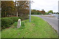
Milestone at junction of Watling Street and Olde Bell Lane
There is an closeup of the milestone at Image and a further photo showing an OS benchmark Image on the far face of the milestone
Image: © Roger Templeman
Taken: 20 Oct 2016
0.18 miles