IMAGES TAKEN NEAR TO
Burchard Crescent, MILTON KEYNES, MK5 6DX
Introduction
This page details the photographs taken nearby to Burchard Crescent, MK5 6DX by members of the Geograph project.
The Geograph project started in 2005 with the aim of publishing, organising and preserving representative images for every square kilometre of Great Britain, Ireland and the Isle of Man.

There are currently over 7.5m images from over14,400 individuals and you can help contribute to the project by visiting https://www.geograph.org.uk
Image Map
Images are licensed for reuse under creativecommons.org/licenses/by-sa/2.0
Notes
- Clicking on the map will re-center to the selected point.
- The higher the marker number, the further away the image location is from the centre of the postcode.
Image Listing (40 Images Found)
Images are licensed for reuse under creativecommons.org/licenses/by-sa/2.0
Image
Details
Distance
3
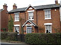
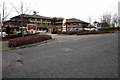
Rose Cottage
Rose Cottage in Shenley Church End.
Image: © George Wilson
Taken: 29 Mar 2007
0.10 miles
4
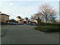
Lipscomb Lane
Looking down Lipscombe lane towards the local shops and restaurant.
Image: © Malcolm Campbell
Taken: 19 Jan 2012
0.10 miles
7
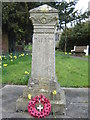
War Memorial
A war memorial at the entrance to the church in Shenley Church End.
Image: © George Wilson
Taken: 29 Mar 2007
0.13 miles
8
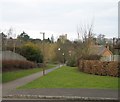
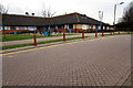
View from Pigott Drive
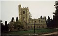
The lane which connects Pigott Drive and Thirlby Lane - showing the top of St Mary's Church at the centre.
Image: © Malcolm Campbell
Taken: 27 Feb 2009
0.13 miles
9
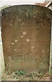
Gravestone
There are many old gravestones in this churchyard.
Image: © Angella Streluk
Taken: 10 Sep 1995
0.14 miles