IMAGES TAKEN NEAR TO
Engaine Drive, MILTON KEYNES, MK5 6BE
Introduction
This page details the photographs taken nearby to Engaine Drive, MK5 6BE by members of the Geograph project.
The Geograph project started in 2005 with the aim of publishing, organising and preserving representative images for every square kilometre of Great Britain, Ireland and the Isle of Man.

There are currently over 7.5m images from over14,400 individuals and you can help contribute to the project by visiting https://www.geograph.org.uk
Image Map
Images are licensed for reuse under creativecommons.org/licenses/by-sa/2.0
Notes
- Clicking on the map will re-center to the selected point.
- The higher the marker number, the further away the image location is from the centre of the postcode.
Image Listing (19 Images Found)
Images are licensed for reuse under creativecommons.org/licenses/by-sa/2.0
Image
Details
Distance
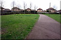
2
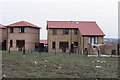
Newly-built houses, Lowndes Grove, Shenley Church End, 1989
Image: © Christopher Hilton
Taken: 18 Mar 1989
0.11 miles
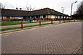
5
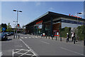
Sainsbury's Supermarket
A fairly modern building which for modern standards is quite a small supermarket. It was, however, very busy.
Image: © Malcolm Neal
Taken: 16 Apr 2022
0.17 miles
6
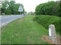
Milestone
Old milestone on what was the A.5 near to Loughton, Milton Keynes. For close up view see http://www.geograph.org.uk/photo/5381064
Image: © Keith Evans
Taken: 22 Apr 2017
0.20 miles
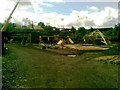
7
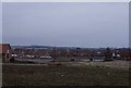
Looking down to Watling Street from Lowndes Grove, 1989
Image: © Christopher Hilton
Taken: 18 Mar 1989
0.21 miles
8
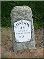
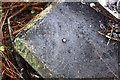
Old Milestone
Old milestone on what was the A.5 near to Loughton, Milton Keynes. For overall view see http://www.geograph.org.uk/photo/5381080
Image: © Keith Evans
Taken: 22 Apr 2017
0.21 miles
9

Gate A
Gate A of the factory SMC Pneumatics.
Image: © Malcolm Neal
Taken: 19 Apr 2022
0.21 miles
10
Benchmark on bridge parapet at Olde Bell Lane / Watling Street junction
Ordnance Survey rivet benchmark described on the Bench Mark Database at http://www.bench-marks.org.uk/bm75369
Image: © Roger Templeman
Taken: 23 Nov 2016
0.21 miles