IMAGES TAKEN NEAR TO
Selby Grove, MILTON KEYNES, MK5 6AQ
Introduction
This page details the photographs taken nearby to Selby Grove, MK5 6AQ by members of the Geograph project.
The Geograph project started in 2005 with the aim of publishing, organising and preserving representative images for every square kilometre of Great Britain, Ireland and the Isle of Man.

There are currently over 7.5m images from over14,400 individuals and you can help contribute to the project by visiting https://www.geograph.org.uk
Image Map
Images are licensed for reuse under creativecommons.org/licenses/by-sa/2.0
Notes
- Clicking on the map will re-center to the selected point.
- The higher the marker number, the further away the image location is from the centre of the postcode.
Image Listing (23 Images Found)
Images are licensed for reuse under creativecommons.org/licenses/by-sa/2.0
Image
Details
Distance
1
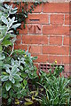
Benchmark on #52 Selby Grove
Ordnance Survey cut mark benchmark described on the Bench Mark Database at http://www.bench-marks.org.uk/bm80579
Image: © Roger Templeman
Taken: 23 Nov 2016
0.07 miles
2
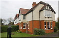
Selby Grove Cottages
There is an OS benchmark Image under the bay window on the side of the nearest house, which was formerly #1 Glastonbury Cottages.
Image: © Roger Templeman
Taken: 23 Nov 2016
0.07 miles
3
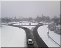
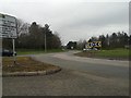
Shenley roundabout
Shenley roundabout in the snow. Showing where Fulmer Street V3 crosses Childs Way H6
Image: © Malcolm Campbell
Taken: 2 Feb 2009
0.07 miles
4
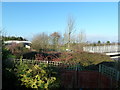
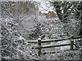
Three footbridges
Three footbridges visible from this point during the winter when the trees are bare.
Image: © Malcolm Campbell
Taken: 22 Dec 2011
0.08 miles
5
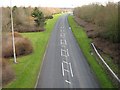
Milton Keynes : Shenley Roundabout
Looking along Shenley Roundabout.
Image: © Lewis Clarke
Taken: 19 Mar 2019
0.08 miles
6
View across the field
Looking towards Braford Gardens across the 'moat' field
Image: © Malcolm Campbell
Taken: 5 Feb 2009
0.14 miles
7
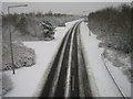
The bend before snowfall
The map doesn't show the extent of this bend along Fulmer Street between Childs Way and Chaffron Way. Nice Shot taken before the weather changed ... see 'The bend after snowfall'
Image: © Malcolm Campbell
Taken: 26 Jan 2009
0.14 miles
8
The bend after snowfall
Once again Fulmer Street bending along between Childs Way and Chaffron Way - not reflected in the map at this scale... contrast this scene with the picture taken on 26 January 2009.
Image: © Malcolm Campbell
Taken: 5 Feb 2009
0.14 miles
9
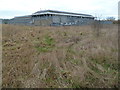
Santander warehouse
Data warehouse or where they store all of the paperwork. Clearly shows the natural grassland which has been left around the site.
Image: © Malcolm Campbell
Taken: 9 Jan 2012
0.14 miles
10
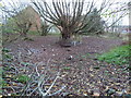
Stump pond
No pond which is very unusual for November - hopefully this will get refilled by the time the dragonflies need to spawn.
Image: © Malcolm Campbell
Taken: 16 Nov 2011
0.14 miles