IMAGES TAKEN NEAR TO
Woodpits Lane, OLNEY, MK46 5NE
Introduction
This page details the photographs taken nearby to Woodpits Lane, MK46 5NE by members of the Geograph project.
The Geograph project started in 2005 with the aim of publishing, organising and preserving representative images for every square kilometre of Great Britain, Ireland and the Isle of Man.

There are currently over 7.5m images from over14,400 individuals and you can help contribute to the project by visiting https://www.geograph.org.uk
Image Map
Images are licensed for reuse under creativecommons.org/licenses/by-sa/2.0
Notes
- Clicking on the map will re-center to the selected point.
- The higher the marker number, the further away the image location is from the centre of the postcode.
Image Listing (5 Images Found)
Images are licensed for reuse under creativecommons.org/licenses/by-sa/2.0
Image
Details
Distance
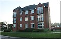
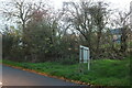
2
Yardley Road at the end of Winterbottom Way
The estate on the left was a field until fairly recently.
Image: © David Howard
Taken: 9 Oct 2022
0.14 miles
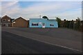
4
Yardley Road, Olney
There were open fields where the houses are only a few years earlier.
Image: © David Howard
Taken: 30 Oct 2022
0.21 miles