IMAGES TAKEN NEAR TO
The Mansions, Pevers Lane, OLNEY, MK46 5JU
Introduction
This page details the photographs taken nearby to The Mansions, Pevers Lane, MK46 5JU by members of the Geograph project.
The Geograph project started in 2005 with the aim of publishing, organising and preserving representative images for every square kilometre of Great Britain, Ireland and the Isle of Man.

There are currently over 7.5m images from over14,400 individuals and you can help contribute to the project by visiting https://www.geograph.org.uk
Image Map
Images are licensed for reuse under creativecommons.org/licenses/by-sa/2.0
Notes
- Clicking on the map will re-center to the selected point.
- The higher the marker number, the further away the image location is from the centre of the postcode.
Image Listing (9 Images Found)
Images are licensed for reuse under creativecommons.org/licenses/by-sa/2.0
Image
Details
Distance
1
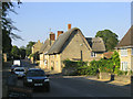
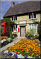
Weston Underwood
This picturesque village is located just a few miles west of Olney, and is a frequent winner of awards for Best Kept Village. It was the home of poet William Cowper from 1785 to 1795 and close to the village, overlooking the countryside, stands The Alcove where Cowper mused and spent much of his time writing.
Image: © John Winfield
Taken: 1 Jul 2006
0.04 miles
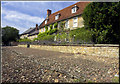
3
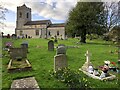
The churchyard at St Lawrence, Weston Underwood
Image: © Philip Jeffrey
Taken: 3 Apr 2021
0.07 miles
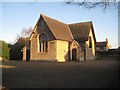
4
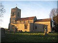
Weston Underwood: Church of St Lawrence
Caught in the low winter setting sun the church is Grade I Listed with the earliest parts dating from the 12th century. The church is only about 1,400 metres away, as the crow flies, from the also Grade I Listed Image
Image: © Nigel Cox
Taken: 8 Feb 2015
0.07 miles
5
Village Post Office, Weston Underwood
Shortly after this photo was taken, the post office was closed, a victim of economy cuts....
Image: © Cameraman
Taken: 24 Jul 2008
0.08 miles
6
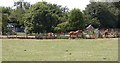
Horses near Children's Play Area
Seen when entering Weston Underwood on a Footpath.
Image: © Kokai
Taken: 16 Jul 2006
0.08 miles
7
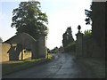
Gated entrance to Weston Underwood
Located at the eastern end of the village.
Image: © John Winfield
Taken: 1 Jul 2006
0.14 miles
8
Weston Underwood: The Village Hall
The Village Hall is on the main road through the village just to the west of Image The photographer thinks this building may have originally been the Village School.
Image: © Nigel Cox
Taken: 8 Feb 2015
0.23 miles
9
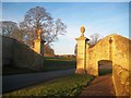
Weston Underwood: Weston House Gate Piers
These stone piers presumably at one time supported gates across the access to Weston House at the north-east end of the High Street in the village. Today the road is a public through route to Olney. The piers are Grade II Listed and the English Heritage website describes them thus:-
"Gatepiers and attached walls. Circa 1700. Stone walls either side swept up in curves to panelled ashlar stone piers on moulded plinths. Panelled sides. Inner pilasters and scroll brackets on outer sides resting on walls, moulded cornices and large carved pineapples on plinths."
The footpath goes through its own small arch on the right.
Image: © Nigel Cox
Taken: 8 Feb 2015
0.25 miles