IMAGES TAKEN NEAR TO
Dinglederry, OLNEY, MK46 5HA
Introduction
This page details the photographs taken nearby to Dinglederry, MK46 5HA by members of the Geograph project.
The Geograph project started in 2005 with the aim of publishing, organising and preserving representative images for every square kilometre of Great Britain, Ireland and the Isle of Man.

There are currently over 7.5m images from over14,400 individuals and you can help contribute to the project by visiting https://www.geograph.org.uk
Image Map
Images are licensed for reuse under creativecommons.org/licenses/by-sa/2.0
Notes
- Clicking on the map will re-center to the selected point.
- The higher the marker number, the further away the image location is from the centre of the postcode.
Image Listing (19 Images Found)
Images are licensed for reuse under creativecommons.org/licenses/by-sa/2.0
Image
Details
Distance
4
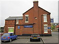
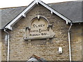
Feoffee Estate Houses,Olney
On searching Googgle to enlighten the description Feoffee is not only difficult to pronounce but its meaning is somewhat ambiguous so I await clarity from a person who knows about such things.
Image: © Michael Trolove
Taken: 22 Feb 2009
0.21 miles
5
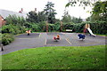
Children's playground by the new housing
Image: © Philip Jeffrey
Taken: 16 Aug 2012
0.21 miles
6
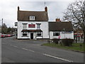
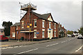
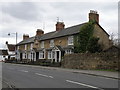
The Castle
Situated at the end of the High Street, the Wellingborough end.
Image: © Michael Trolove
Taken: 22 Feb 2009
0.22 miles
7
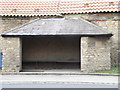
Coronation Bus Shelter
Built in 1952 to honour the coronation of the reigning Monarch.
Image: © Michael Trolove
Taken: 22 Feb 2009
0.22 miles