IMAGES TAKEN NEAR TO
Heritage Court, OLNEY, MK46 5FW
Introduction
This page details the photographs taken nearby to Heritage Court, MK46 5FW by members of the Geograph project.
The Geograph project started in 2005 with the aim of publishing, organising and preserving representative images for every square kilometre of Great Britain, Ireland and the Isle of Man.

There are currently over 7.5m images from over14,400 individuals and you can help contribute to the project by visiting https://www.geograph.org.uk
Image Map
Images are licensed for reuse under creativecommons.org/licenses/by-sa/2.0
Notes
- Clicking on the map will re-center to the selected point.
- The higher the marker number, the further away the image location is from the centre of the postcode.
Image Listing (5 Images Found)
Images are licensed for reuse under creativecommons.org/licenses/by-sa/2.0
Image
Details
Distance
1
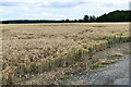
Footpath to Olney from Clifton Pastures
The footpath leaves the Emberton-Clifton Reynes road at Clifton Pastures and heads off across the field to a footbridge over the River Great Ouse visible in the mid distance. The path connects with a bridleway that arrives closeby to the clearly visible church and spire in Olney where John Newton was curate and William Cowper, the poet, was his friend and fellow worshipper.
Image: © Nigel Stickells
Taken: 29 Jan 2007
0.10 miles
2
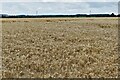
Stile & Footpath at Clifton Pastures
This stile leads from the Emberton-Clifton Reynes road at Clifton Pastures and heads towards an unnamed spinney, visible on the skyline. It continues several miles onwards, wandering aimlessly through empty fields. The footpath is well marked here by the tractor tracks across the ploughed field.
Image: © Nigel Stickells
Taken: 29 Jan 2007
0.10 miles
3
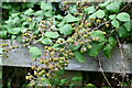
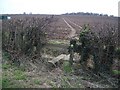
Clifton Reynes: Abundant blackberries here
Image: © Michael Garlick
Taken: 25 Jul 2023
0.13 miles