IMAGES TAKEN NEAR TO
Yardley Road, OLNEY, MK46 5EL
Introduction
This page details the photographs taken nearby to Yardley Road, MK46 5EL by members of the Geograph project.
The Geograph project started in 2005 with the aim of publishing, organising and preserving representative images for every square kilometre of Great Britain, Ireland and the Isle of Man.

There are currently over 7.5m images from over14,400 individuals and you can help contribute to the project by visiting https://www.geograph.org.uk
Image Map
Images are licensed for reuse under creativecommons.org/licenses/by-sa/2.0
Notes
- Clicking on the map will re-center to the selected point.
- The higher the marker number, the further away the image location is from the centre of the postcode.
Image Listing (9 Images Found)
Images are licensed for reuse under creativecommons.org/licenses/by-sa/2.0
Image
Details
Distance

4
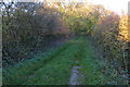
Young woodland by the Pastures Farm pond
Image: © Philip Jeffrey
Taken: 31 Oct 2015
0.15 miles
6
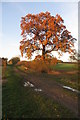
Golden tree on the track towards Old Pond Close
Image: © Philip Jeffrey
Taken: 31 Oct 2015
0.18 miles
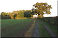
9
Farmland north of Olney
East of the B5388 Olney - Yardley Hastings road.
Image: © Stephen McKay
Taken: 2 Jun 2007
0.19 miles