IMAGES TAKEN NEAR TO
Hulton Drive, OLNEY, MK46 5BY
Introduction
This page details the photographs taken nearby to Hulton Drive, MK46 5BY by members of the Geograph project.
The Geograph project started in 2005 with the aim of publishing, organising and preserving representative images for every square kilometre of Great Britain, Ireland and the Isle of Man.

There are currently over 7.5m images from over14,400 individuals and you can help contribute to the project by visiting https://www.geograph.org.uk
Image Map (Loading...)


Getting Data...Please wait
Leaflet Map data © OpenStreetMap
Images are licensed for reuse under creativecommons.org/licenses/by-sa/2.0
Notes
- Clicking on the map will re-center to the selected point.
- The higher the marker number, the further away the image location is from the centre of the postcode.
Image Listing (12 Images Found)
Images are licensed for reuse under creativecommons.org/licenses/by-sa/2.0
Image
Details
Distance
4
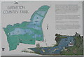
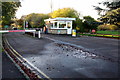
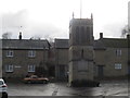
Plan of Emberton Country Park
At the main café and parking area.
Image: © M J Richardson
Taken: 11 Feb 2018
0.16 miles
6
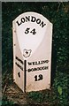
Old Milepost by the A509 near Emberton Country Park
Cast iron post by the A509, in parish of Emberton (Milton Keynes District), Newport Road; 100m North of junction to Emberton Country Park, on wide verge, set in concrete, on East side of road. Barwell iron casting, erected by the Kettering & Newport Pagnell turnpike trust in the 19th century.
Inscription reads:-
: NEWPORT- / -PAGNELL / 4 : : LONDON / 54 : : WELLING- / -BOROUGH / 12 :
Maker:-
: BARWELL & Co / {eagle motif} / FOUNDRY / NORTHAMPTON :
Milestone Society National ID: BU_NPWB04
Image: © A Rosevear & J Higgins
Taken: 3 Aug 2003
0.21 miles
8
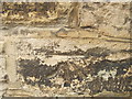
Ordnance Survey Cut Mark
This mark can be found on the wall of a house in Olney Road.
For more detail see : http://www.bench-marks.org.uk/bm46425
Image: © Peter Wood
Taken: 27 Nov 2012
0.22 miles
9
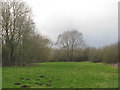
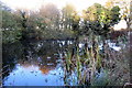
Large Willow at Emberton Country Park
Surrounded by smaller willows and other trees, and with signs of Moles in the grassy area.
Image: © M J Richardson
Taken: 11 Feb 2018
0.23 miles
10
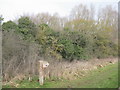
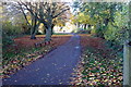
Emberton Country Park
Path to the conservation area, with orange lichen-covered willows being smothered by Ivy.
Image: © M J Richardson
Taken: 11 Feb 2018
0.23 miles