IMAGES TAKEN NEAR TO
Bay Lane, OLNEY, MK46 5AT
Introduction
This page details the photographs taken nearby to Bay Lane, MK46 5AT by members of the Geograph project.
The Geograph project started in 2005 with the aim of publishing, organising and preserving representative images for every square kilometre of Great Britain, Ireland and the Isle of Man.

There are currently over 7.5m images from over14,400 individuals and you can help contribute to the project by visiting https://www.geograph.org.uk
Image Map
Images are licensed for reuse under creativecommons.org/licenses/by-sa/2.0
Notes
- Clicking on the map will re-center to the selected point.
- The higher the marker number, the further away the image location is from the centre of the postcode.
Image Listing (23 Images Found)
Images are licensed for reuse under creativecommons.org/licenses/by-sa/2.0
Image
Details
Distance
1
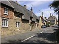
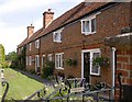
Thatch
Thatched houses in the village of Ravenstone.
Image: © Kokai
Taken: 16 Jul 2006
0.02 miles
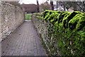
4

Thatched gate to the church and bus shelter
Image: © Philip Jeffrey
Taken: 12 Jan 2013
0.09 miles
6
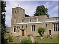
All Saints Church, Ravenstone
Said to have fine stained glass windows, mainly from C19th and C20th.
Image: © Kokai
Taken: 16 Jul 2006
0.10 miles
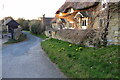
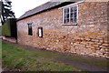
7
Former Almshouses
Viewed from the churchyard, Ravenstone.
Image: © Kokai
Taken: 16 Jul 2006
0.10 miles
8
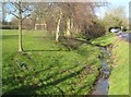
Ravenstone: The stream
This little stream runs down through the middle of the village. Only about 2 kilometres further downstream it joins the vastly larger River Great Ouse.
Image: © Nigel Cox
Taken: 8 Feb 2015
0.10 miles
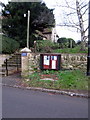
10
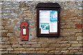
George V postbox and Parish notices
Image: © Philip Jeffrey
Taken: 12 Jan 2013
0.11 miles