IMAGES TAKEN NEAR TO
Abbey Way, OLNEY, MK46 5AP
Introduction
This page details the photographs taken nearby to Abbey Way, MK46 5AP by members of the Geograph project.
The Geograph project started in 2005 with the aim of publishing, organising and preserving representative images for every square kilometre of Great Britain, Ireland and the Isle of Man.

There are currently over 7.5m images from over14,400 individuals and you can help contribute to the project by visiting https://www.geograph.org.uk
Image Map
Images are licensed for reuse under creativecommons.org/licenses/by-sa/2.0
Notes
- Clicking on the map will re-center to the selected point.
- The higher the marker number, the further away the image location is from the centre of the postcode.
Image Listing (25 Images Found)
Images are licensed for reuse under creativecommons.org/licenses/by-sa/2.0
Image
Details
Distance
1

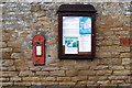
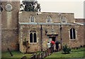
Thatched gate to the church and bus shelter
Image: © Philip Jeffrey
Taken: 12 Jan 2013
0.04 miles

10

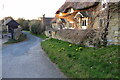
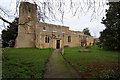
Ravenstone: All Saints' Church
Caught in the low winter setting sun the church is Grade I Listed with the earliest parts dating from the 11th century. The pergola in front is a somewhat unusual feature to have in a church graveyard.
Image: © Nigel Cox
Taken: 8 Feb 2015
0.07 miles